

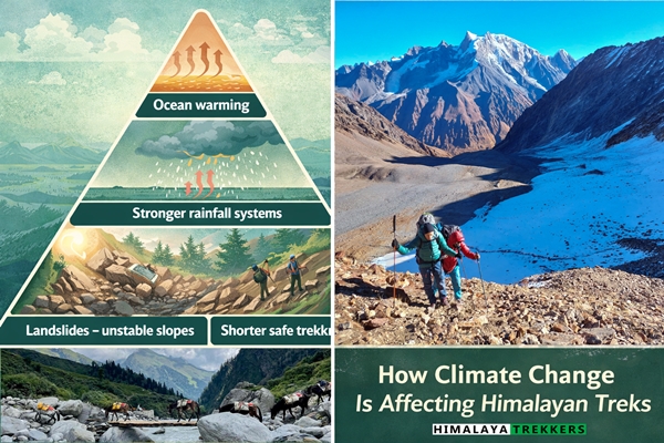
If you return to a Himalayan trail after a decade or so, you’ll feel things are different. The snow patches sit higher than you remember. Rainstorms arrive harder and shorter. The road that once stayed reliable through early October closes without warning after a single night of heavy rain in the middle.
Each of these things, on its own, is not necessarily alarming. Mountain weather has always been unpredictable. But when I hear the same observations from our guides in Sikkim, from forest department staff in Garhwal, and from repeat trekkers who have been walking these routes since the 2000s, I pay attention. A pattern is forming.
The Himalayas are warming, and at an alarming pace. I presume, the question that matters for a trekker is not whether to go. It is how to go wisely, with an honest picture of what has changed and what that means for your planning.
This article is my attempt to give you that picture, from the ground up.
The Himalaya Is Warming Faster Than You Might Expect
There is a well-documented phenomenon called elevation-dependent warming. Mountain regions, particularly above 3,000 m, tend to warm faster than the global average. The reason is connected to snow and ice cover. As that cover shrinks, darker rock and soil absorb more sunlight rather than reflecting it. This accelerates local warming further.
In the Indian Himalaya, studies indicate warming rates of roughly 0.15 to 0.60 degrees Celsius per decade in high-altitude zones – faster than the plains below. For context, that is a meaningful shift within a single trekking lifetime.
What this produces on the ground is not a simple story of things getting warmer. It is a story of things becoming more variable and less predictable. That unpredictability is the real challenge for trekking.
Glacier Retreat – What You Can Actually See
The Gangotri Glacier in Uttarakhand is probably the clearest example for trekkers. It is the source of the Bhagirathi river and one of the most studied glaciers in India. Since 1935, its snout has retreated by approximately 1,700 metres. In recent decades the pace of retreat has accelerated.
If you compare the photographs from a Gaumukh-Tapovan trek taken around 2007 and compare them with images from 2022, the difference is visible even to an untrained eye. The ice front has moved further upstream. Moraine fields and exposed rock now occupy ground that once held solid glacier. Meltwater channels have multiplied and shifted.
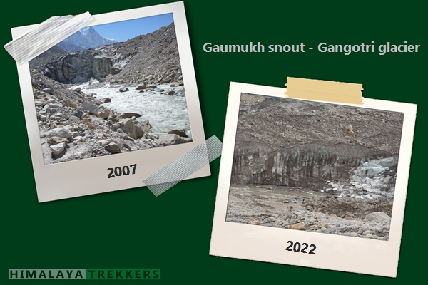
For trekkers at Gaumukh, this means the terrain is more unstable than it looks. Loose moraine is deceptive underfoot. The landscape around the snout is dynamic in ways that older trekking guides do not describe.
In Sikkim, the Zemu Glacier – the largest glacier in the eastern Himalaya – is undergoing similar retreat. It is not directly on a popular trekking route, but it feeds the Teesta river system that the entire region depends on. Its condition matters beyond aesthetics. On the other hand, Rathong Glacier is receding day by day, making it more difficult for Himalayan Mountaineering Institute students to train themselves on snow and ice.
The South Lhonak GLOF – A Case Study Every Trekker in Sikkim Should Know
I want to spend some time on this, because it is the most consequential climate-related event in our operating region in a decade, and most trekking articles still do not mention it properly.
On the night of 3-4 October 2023, a large section of frozen moraine above South Lhonak Lake in North Sikkim gave way. The lake sits at approximately 5,200 m. Scientists had been monitoring it for years – it had grown from roughly 0.2 sq km in 1976 to over 1.67 sq km by 2023. The warning signs were well documented. The Geological Survey of India had flagged the lake as a GLOF risk as early as 2013.
When the collapse happened, an estimated 50 million cubic metres of water discharged into the Teesta river valley below. The flood destroyed the Teesta III hydroelectric dam near Chungthang. It took out 31 bridges across Sikkim. It stranded approximately 3,000 tourists in the state, killed 129 people, and severed NH-10 – the national highway that connects Siliguri to Gangtok and is the main approach road for trekkers heading toward Yuksom, Lachen, and the Goechala corridor.
I am not sharing this to alarm anyone. A GLOF of that magnitude is a rare event. But its effects on the trekking infrastructure of Sikkim were not rare at all – they were immediate, severe, and long-lasting. As of 2025, parts of the NH-10 and North Sikkim road network are still being rebuilt. Our own planning for Sikkim departures now carries an explicit road-condition buffer that did not exist five years ago.
This is what a GLOF actually means in trekking terms. Not just scientific interest. Disrupted routes, uncertain access, and changed departure logistics.
The broader point is this: glacial lakes are growing across the Himalaya. Most remain stable. But the risk of outburst events is increasing, and the infrastructure consequences tend to land on trekking access corridors more often than on the trails themselves.
The Snowline Paradox
Here is something that confuses a lot of trekkers. You would expect a warming Himalaya to simply mean less snow. And broadly, that is true – snowlines are gradually moving higher, and routes that once held reliable snow through April may now be largely clear by late March.
But there is a counterintuitive flip side. Warmer air carries more moisture. When a storm system does arrive, it can dump significant snowfall very quickly – more than earlier seasons produced in comparable time. So you get less consistent snow overall, but occasional intense snowfall events that catch trekkers off guard.
I have seen this on Kedarkantha, on the Roopkund approaches, and on sections of the Goechala trail. The calendar-based assumption – “it is mid October, snowfall is unlikely” – no longer holds the way it once did. In some recent years a single western disturbance in late October has deposited 40-60 cm of fresh snow on passes that were completely clear the week before.
There is a secondary effect worth noting: the treeline in many Himalayan regions is slowly climbing. Rhododendron and birch forest are appearing at elevations that were previously open alpine terrain. This is subtle and slow, but repeat visitors do notice it. The character of certain trails is shifting alongside the hazards.
For planning purposes, the lesson is simple. Check snow conditions specific to your travel date, not just the general season. Calendar assumptions are a starting point, not a decision.
Rainfall, Landslides, and Why the Road Is Now Your Biggest Variable
Mountain trails are generally more resilient to climate change than approach roads. I want to make that distinction clearly, because I think it matters for how trekkers assess risk.
A steep trail may erode faster during intense monsoon rainfall. A river crossing may be more swollen than expected. These are genuine concerns. But the more common disruption I see is not on the trail – it is on the 8-12 hours of road travel that gets a trekker to the trailhead in the first place.
The Badrinath highway is one example. Intense rainfall events in Uttarakhand now close that road several times each season, sometimes for days. The Uttarkashi-Gangotri route has a similar history. In Sikkim, as I described above, the 2023 GLOF left road infrastructure in a state that still affects access timelines. In Himachal, the Kullu and Kinnaur valleys see regular road closures after heavy rain, affecting routes toward Kinner Kailash and Chandratal.
The reason landslide frequency is increasing involves three factors that interact. Intense rainfall bursts saturate hillside soil faster than drainage can manage. Glacier retreat leaves unstable moraine slopes behind. And expanding road construction – often through geologically fragile terrain – creates new failure points.
None of this means trekking is becoming dangerous in a general sense. It means that rigid travel schedules are becoming a liability. A trekker who absolutely must be back in Delhi by a specific date is more exposed than one who has built flexibility into the return journey.
When Conservation Meets Climate – How Trekking Access Is Changing
This is an angle I think deserves more attention than it typically gets, partly because it directly affects routes we operate.
Take the Goechala trek in Sikkim. A few years ago, trekkers routinely reached Goechala Pass itself, at around 4,940 m, for views of the Kanchenjunga massif at close range. Gradually, the permitted endpoint was moved back. Today the standard trekking limit sits at what is commonly called Sunrise Point or Viewpoint 1, well short of the actual pass.
The official reasons involve environmental protection and wildlife conservation within the Kanchenjunga National Park buffer zone. Whether climate stress, biodiversity pressure, or simple overuse is the primary driver, I cannot say definitively. Probably all three interact. What I do know is that the policy changed, and trekkers who arrive expecting old guidebook-era access are sometimes surprised.
The Neora Valley National Park situation is another example. Night stays near the Rachela Pass route have remained restricted since the COVID period. Anecdotally, forest officials in the region cited a camera trap record of a tiger at unusually high altitude as one of the contributing factors. Whether that sighting was directly linked to climate-driven range shifts or to other ecological reasons is open to discussion. But it illustrates how wildlife behaviour, conservation response, and trekking access are increasingly connected.
We expect these policy adjustments to continue. Climate stress on fragile ecosystems does not slow down, and forest authorities are responding to real pressures. My advice to trekkers is to treat permitted access as current information to verify, not as a fixed fact from any guidebook or old blog.
What Is Actually Happening to Trekking Seasons
The traditional seasonal advice still broadly holds. Spring (roughly March to May) and post-monsoon autumn (October to mid-November) remain the most reliable trekking windows in most regions. I am not suggesting those frameworks are obsolete.
What I am saying is that the reliable sub-window within each season has become narrower and less certain.
In the eastern Himalaya (Sikkim and Darjeeling), the monsoon withdrawal has become more variable. Years where October starts wet and unstable are not unusual anymore. The window between late September and late October, which was once quite predictable, now needs active monitoring.
In Garhwal and Kumaon, autumn rainfall occasionally extends longer than traditional wisdom suggests. And western disturbance systems in late October can bring snow to passes that earlier generations of trekkers would have considered safe until November.
In Ladakh and the Zanskar-Spiti belt, the climate dynamics are different because these regions sit in a rain shadow. But even here, the increasing frequency of flash floods in summer has made July-August logistics more complicated than they once were.
The practical shift is this: instead of choosing a month and booking fixed dates, plan around a weather window. Monitor IMD forecasts, cross-check with ECMWF model guidance, and make a final departure decision in the 5-7 day range before you move. This is now standard practice in how we plan our own departures at HT.
How to Actually Plan a Himalayan Trek in a Changing Climate
I intend to write something more useful than a generic checklist here.
The first thing to understand is that weather forecasting in the Himalaya has genuinely improved. You are not navigating blind. The India Meteorological Department publishes district-level forecasts that are reasonably accurate at the 3-5 day range. For mountain-specific conditions, ECMWF model runs and ensemble spreads help indicate forecast confidence – whether models agree or diverge tells you something important about uncertainty. Tools like Windy and Meteoblue give visual access to these outputs without needing to read raw model data.
The second thing is to build your itinerary around a window rather than a date. If I am planning a trek that needs 9 days of walking, I plan for a 13-14 day total trip. Those extra days are not wasted padding. They are insurance against the road that closed, the afternoon storm that kept us at camp, the buffer that turns a crisis into a minor inconvenience.
The third thing – and I cannot emphasise this enough – is to respect local information. Our guides and coordinator in Sikkim, Garhwal, Himachal or be it Kashmir, have been watching these mountains for decades. They notice micro-changes that no weather model captures. When a guide says the stream crossing looks different this year, that observation is data.
Another measure is having a Plan B or taking help of a trekking tour operator who can tailor an alternate on the fly due to any showstopper.
Finally, the environmental dimension. Climate change is partly a consequence of the cumulative choices that travellers and businesses make. Travelling lighter matters – not symbolically, but because it reduces extraction pressure on fragile landscapes. Reusing equipment rather than buying new kit for every trek matters. Choosing operators who actively manage their waste and staff welfare matters. At HT, the “Live Green, Trek Green” principle shapes how we run trips, not just what we say on a website. If these mountains are going to remain worth visiting for the next generation, the responsibility is shared.
Frequently Asked Questions
Is Himalayan trekking still safe given climate change? Yes, trekking in the Indian Himalaya remains safe when planned responsibly. Climate change has increased variability and unpredictability, not made trekking inherently dangerous. The main adjustments are flexible scheduling, active weather monitoring, and choosing operators who plan for uncertainty rather than assuming fixed conditions.
How has the best time to trek in the Himalayas changed? The traditional spring and autumn windows still work broadly. What has changed is the certainty within those windows. Both seasons are showing more variability at the edges – autumn sometimes runs wetter into October, spring snowmelt sometimes accelerates unpredictably. Planning around a forecast window rather than a fixed departure date is now more important than it used to be.
What is a GLOF and should trekkers worry about it? A Glacial Lake Outburst Flood (GLOF) occurs when a moraine or ice dam holding a glacial lake fails, releasing large volumes of water rapidly downstream. For trekkers, the direct on-trail risk is low because most glacial lakes are far from common routes. The bigger impact is on access roads and infrastructure downstream – the South Lhonak GLOF in Sikkim in October 2023 is the clearest recent example of this. It destroyed 31 bridges and severed the main highway to Gangtok.
Why has the Goechala trekking limit changed? The permitted trekking endpoint for Goechala has been moved back from the actual pass to Sunrise Point (Viewpoint 1) over time. The decision is connected to environmental protection and wildlife conservation within the Kanchenjunga National Park buffer zone. Access policies on ecologically sensitive routes in the Himalaya are subject to revision, and trekkers should verify current permits and permitted endpoints before booking rather than relying on older sources.
Should I cancel my Himalayan trek because of climate risks? No. Climate change calls for adaptation, not withdrawal. Trekkers who plan flexibly, monitor weather actively, travel with experienced operators, and approach the mountains with patience will find the Himalaya as rewarding as it has ever been. The mountains are changing. Our response to that should be awareness and humility, not avoidance.
The Mountains Are Changing – But They Still Teach
The Himalaya has never been static. Glaciers have advanced and retreated across geological time. Rivers shift their channels. Species move. The mountains are always in process.
What climate change is doing is accelerating certain parts of that process within a human timescale – within our trekking lifetimes. That makes it personal in a way that purely geological change is not.
I still believe these mountains are among the most extraordinary places a person can walk. I would not run a trekking company if I did not. But the respect they ask of us is no longer optional – not in planning, not in behaviour on trail, and not in the cumulative choices we make about how we travel.
Come with flexibility. Come prepared. Listen to the mountain, and listen to the people who live near it.
The rewards are unchanged. The conditions demand more of us than they once did.
Planning a trek and want to understand the current conditions or what conditions would be like on a specific route or region? Contact us at the below and we will give you an honest picture before you book.
Explore 55 Himalayan treks—from beginner-friendly meadows to summit, tea-house homestays to remote high-pass expeditions. Browse by region below to find current, field-tested itineraries across Uttarakhand (Garhwal & Kumaon), Himachal (including Lahaul–Spiti and Kinnaur), Ladakh & Kashmir, and the Eastern Himalaya (Sikkim, Darjeeling–Kalimpong). Each archive links to live trip pages with dates, altitude profiles, gear notes and realistic pacing.



Comments