Uttarakhand
Bali Pass Trek
Uttarakhand (May, Jun,Sep,Oct)
- Duration
- 8 Days
- Max Altitude
- 4880 m
- Trail
- 58 km
- From
- ₹24,500
We run the Kedartal trek as limited seasonal group departures (check availability) or as a private/custom itinerary on your preferred dates. Season status: The post-monsoon season begins around the middle of Sep and lasts in autumn till the end of Oct.
snapshot
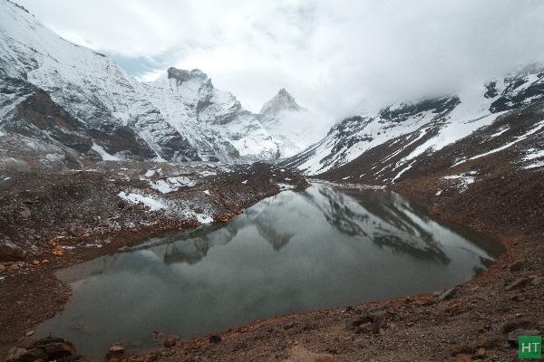
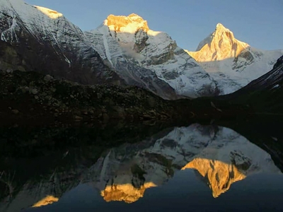
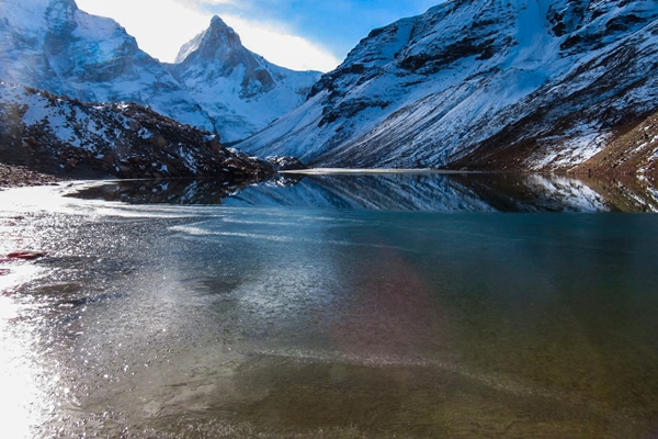
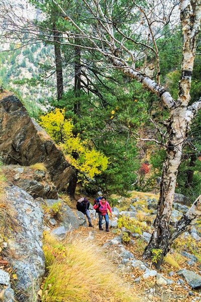
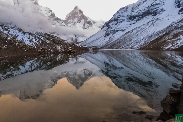
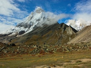
The Kedartal trek is short, yet it is a very rewarding trail that begins at the holy Shrine of Gangotri in Gangotri National Park, Uttarakhand. This out-and-back trail reaches a high point at Kedartal, 4,725 m (15,500 ft), a glacial lake, and is suitable for you who remained fit at altitude before. The trail features deodar and birch forests, open campsites, gushing stream crossings, boulder shelves and moraine, balancing short exposed traverses or loose gravel, and almost all the high-altitude character you would expect. The grand moment is set when towering Thalaysagar and Bhrigupanth peaks mirror on calm and turquoise Kedartal.
experience
At a glance: Gangotri temple & acclim walks | Birch forest & narrow shelves | Spider Wall traverse | Meadow camps at Kedar Kharak | Lake-basin reflections | Close views of Thalaysagar, Bhrigupanth & Jogin group of peaks| Blue sheep & wild terrain | Exit same route
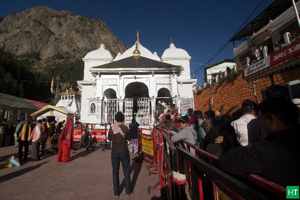
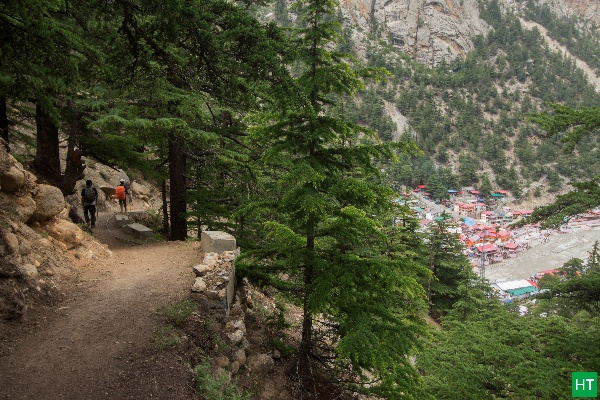
After a day-long drive from Dehradun you are finally at Gangotri (3,100 m / 10,200 ft), a Char Dham shrine town and the traditional start point. Acclimatisation walks to Gauri Kund and Bhagirath Shila help you settle before the trail steepens.
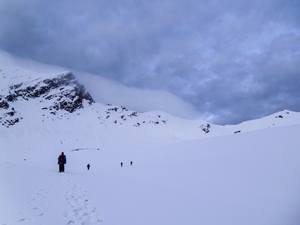
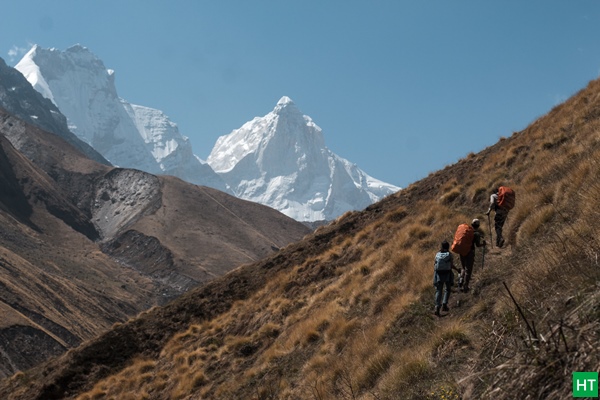
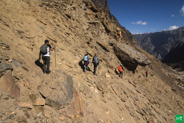
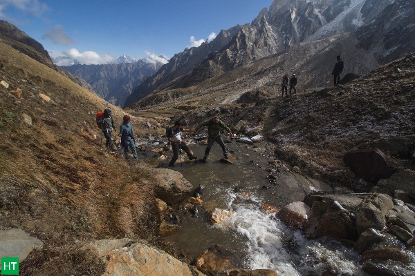
The first climbing section passes deodar and pine before birch takes over. After 7-8 km and 5-6 hours of steady ascent, you reach Bhoj Kharak (3,900 m / 12,800 ft) on a narrow ledge.
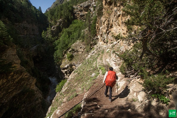
Beyond Bhoj Kharak the route contours across the Spider Wall, a short but exposed rock traverse. This demands balance and caution, especially when the rock is wet. The forest dept sometimes builds a makeshift path digging up residue snow bridges and creating short wooden pools. However, these makeshift paths are temporary.
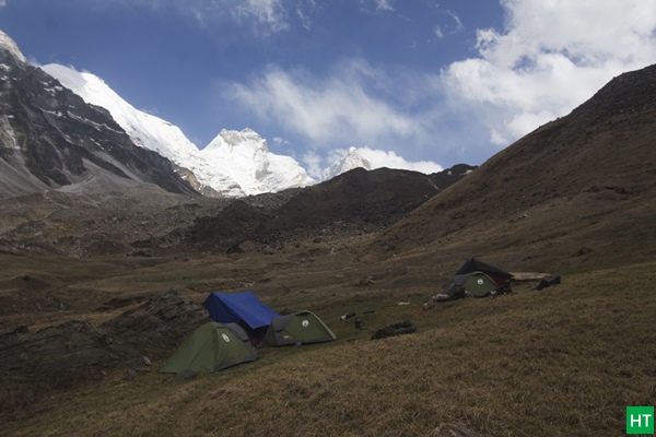
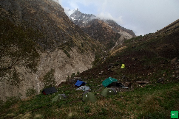
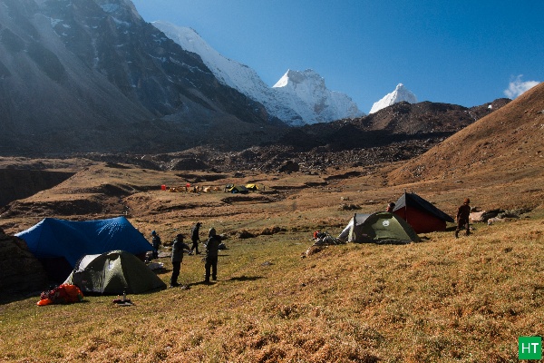
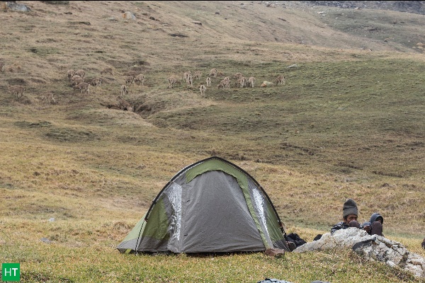
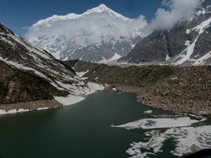
The valley widens at Kedar Kharak (4,630 m / 14,350 ft), a grassy campsite ringed by glaciers. It is an ideal acclimatisation halt, with long perspectives up to the hanging icefalls.
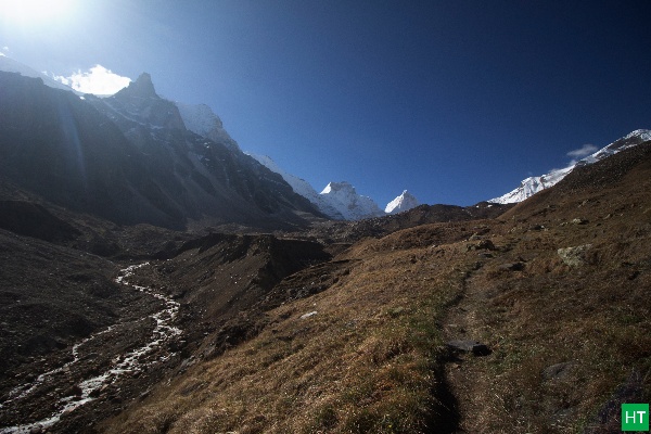
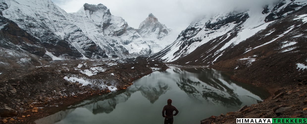
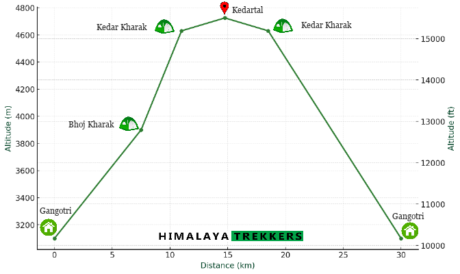
From Kedar Kharak, the moraine walk begins. The 3 to 4 km push to Kedartal takes 2-3 hours one way, across loose stone, rock and boulder fields. Your effort is rewarded when you arrive at Kedartal, a longitudinal crescent-shaped lake at 4,725 m / 15,500 ft.
When conditions are calm, the lake turns mirror-still. Kedartal reflects Thalay Sagar and Bhrigupanth cleanly across the water. We make a measured halt here and turn back to Kedar Kharak camp before the weather changes.
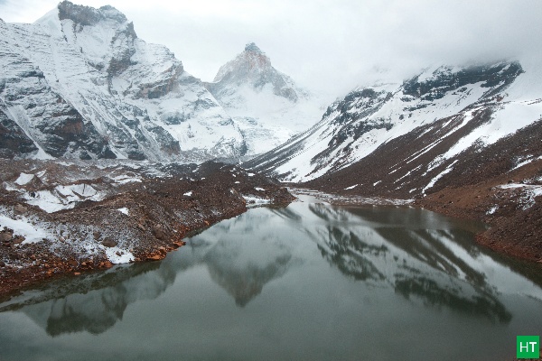
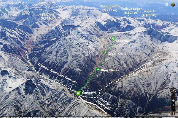
Peaks you see: East to west — Thalay Sagar (6,904 m), Bhrigupanth (6,772 m), Jogin peaks (~6,400–6,800 m), and Meru (6,672 m).
From Kedar Kharak a moderately long descent through the same route takes us back to Gangotri.
difficulty & readiness
The Kedartal Trek is a strenuous journey that requires both physical fitness and mental fortitude. This is not at all a fit beginner’s trail.
We don’t use hard age cut-offs. Suitability is case-by-case after a quick chat on recent activity, health and comfort at altitude.
day wise plan
DAY 1 Drive from Dehradun to Gangotri (∼3100m / 10200ft) – 260 km – 10/12 hours – Hotel/Lodge.
DAY 2 Active Acclimatisation at Gangotri to Gauri Kund, Pandav Gufa, Bhagirath Shila etc – 2-3 hours – Hotel/Lodge.
DAY 3 Trek to Bhoj Kharak (∼3900 m / 12800 ft) – 7-8 km, 5 to 6 hours. Twin sharing tent.
DAY 4 Trek to Kedar Kharak (∼4630 m / 14350 ft) – 3-4 km, 3 to 4 hours. Camp
DAY 5 Trek to Kedartal (∼4725m / 15500 ft) and return to Kedar Kharak camp – to and fro 7-8 km, 4 to 5 hours.
DAY 6 Descend to Gangotri (∼3100m / 10200 ft) – 11-12 km – 5 to 6 hours – Hotel/Lodge
DAY 7 Drive back to Dehradun – 240 km – 10/12 hours
⚠ Distances/altitudes are approximate; walking time assumes a moderately fit pace. Itinerary may adjust to weather, road and Gangotri National Park openings (typically opens by mid to late April and closes by early Nov). Keep buffer days.
| Day | Distance
(km) |
Approx time
(hrs) |
Start
(m) |
End
(m) |
Gain/Loss
(m) |
|---|---|---|---|---|---|
| 1 | ~260 (drive) | 10–12 | Dehradun ~640 | Gangotri ~3,100 | +2,460 |
| 2 | 2–3 (walk) | 2–3 | 3,100 | 3,100 | +0 |
| 3 | 7–8 | 5–6 | 3,100 | 3,900 | +800 |
| 4 | 3–4 | 3–4 | 3,900 | 4,630 | +730 |
| 5 | ~5 up + return | 4–5 | 4,630 | 4,725 | +95/–~95 |
| 6 | 11–12 | 5–6 | 4,630 | 3,100 | –1,530 |
| 7 | ~260 (drive) | 10–12 | 3,100 | Dehradun ~640 | –2,460 |
when to go
This is a typical high-altitude trail suitable for trekking during two short and distinct seasons, which are:
The trail opens by early May when snow remains intact above Bhoj Kharak and Kedartal. Days are longer as we proceed to June with some chances of afternoon showers. Days are warm with still cold nights. Views are good, with occasional chances of haze. Overall conducive for trekking.
Usually by the end of June, the monsoon arrives. During July and August the trail is not recommended, and the long approach/motor road to the basecase gets interrupted. Although the monsoon should recede by late August, climate change plus mountain weather systems may still push it until the middle of September.
Season sets in by early Sep and continues till late Oct. Cleaner air after the monsoon, crisp views of the mountains. Days are cool, and nights are colder as we progress. Some chances of rain in early Sep, whereas early seasonal snowfall from mid-Oct is a possibility.
| Month | Feasibility | Access/Road | Rain/Snow | Views | Notes |
|---|---|---|---|---|---|
| May | High | Open | Snowfields linger | Good | Nights often <0°C in camps |
| Jun | High | Open | PM showers | Good | Warmer lower camps |
| Jul–Aug | Not feasible | Landslide risk | Heavy rain | Poor | Avoid |
| Sep | High | Open | Residual showers in the early half | Excellent | Clear skies, still green, night temps goes below freezing |
| Oct | High | Open | Early snow likely from mid-half | Excellent | Foliage, winter layers needed, ⪃ -10°C in camps |
| Nov–Apr | Closed | Snowbound | Heavy snow | – | Trail inaccessible, no permits |
Mountain weather changes quickly; treat season windows as guidance and check forecasts in the week you travel.
maps & charts
The map and chart below add a clear visual layer to the trek description above.
Start with the satellite image of route map → it gives readers a bird’s-eye, spatial sense of where and how the trek unfolds.
Follow with the altitude profile → it anchors the effort and vertical gain/loss.
altitude safety
permits
Any required permits for this itinerary are arranged by us. Carry original government photo ID. We will advise on your final route/itinerary and obtain paperwork as applicable.
entry & exit
Start/finish: The Kedartal trek begins and finishes in Gangotri town, which is 260 km and a day long journey from Dehradun city to reach or return.
| Access hub | Base / End point |
|---|---|
| Nearest Rail: Dehradun (DDN) • Nearest Airport: Dehradun Jolly Grant (DED) | Base — Gangotri • End — Gangotri (return) |
cost
Displayed price reflects FD (when scheduled). For custom/private dates, use the matrix as a guide; final quotes vary by group size, transport and season.
GROUP FIXED DEPARTURE (FD) TREK FEE: ₹ 24,950 (Gangotri to Gangotri) + 5% GST
| Band | Approx per person cost (₹) + 5% GST |
|---|---|
| FD (when available) | 24,950 |
| Custom 2–3 | 55,000 |
| Custom 4–6 | On request |
| Custom 7–10 | On request |
| 11+ (quote) | On request |
gear
For a complete, trek-ready kit, start with our detailed packing list.
Next, learn how to choose the right gear for your trek, balancing weight, durability, comfort, and safety.
Not sure whether to rent or invest? Read why purchasing key gear can be wiser than renting repeatedly.
And once you’ve got your kit, our guide to packing a rucksack will help you carry weight comfortably and keep essentials handy.
ethos
faq
Is the Kedartal trek suitable for beginners?
No, the Kedartal trek is graded as difficult and is not suitable for absolute beginners. Prior high-altitude trekking experience and excellent physical fitness are essential.
What kind of fitness level is required?
You should be able to run 5 km in 30-35 minutes and be comfortable with walking for 6-8 hours with a moderate backpack. Regular strength training is also highly recommended.
Are there proper toilets on the trek?
At campsites, we set up toilet tents (pit-style or dry toilets). In the wilderness, you’ll need to use designated spots away from water sources and practise proper waste disposal (e.g., burying human waste).
What kind of food will be provided?
We provide nutritious and hygienic vegetarian meals, including breakfast, lunch, and dinner, along with morning and evening tea. Expect a mix of Indian and a few continental/Chinese dishes, designed to provide ample energy.
Do I need to carry my own tent or sleeping bag?
No, we provide high-quality tents, sleeping bags, and sleeping mats. You only need to carry your personal backpack.
expertise
We are a small, field-led team that prefers quieter trails, responsible groups and honest pacing. Our aim is simple: keep you safe, comfortable and immersed—so the walking and the places do the talking. We stay reachable from planning to debrief and iterate these pages after every season.
booking
Please read our Booking & Cancellation Policy and Terms & Conditions before you book.
Feel free to get in touch to create your own tour in Spiti.

Uttarakhand
Uttarakhand (May, Jun,Sep,Oct)
Uttarakhand
Uttarakhand (May,Jun,Sep,Oct)
Uttarakhand
Uttarakhand (May,Jun,Sep,Oct)
Tour Reviews
There are no reviews yet.
Leave a Review