
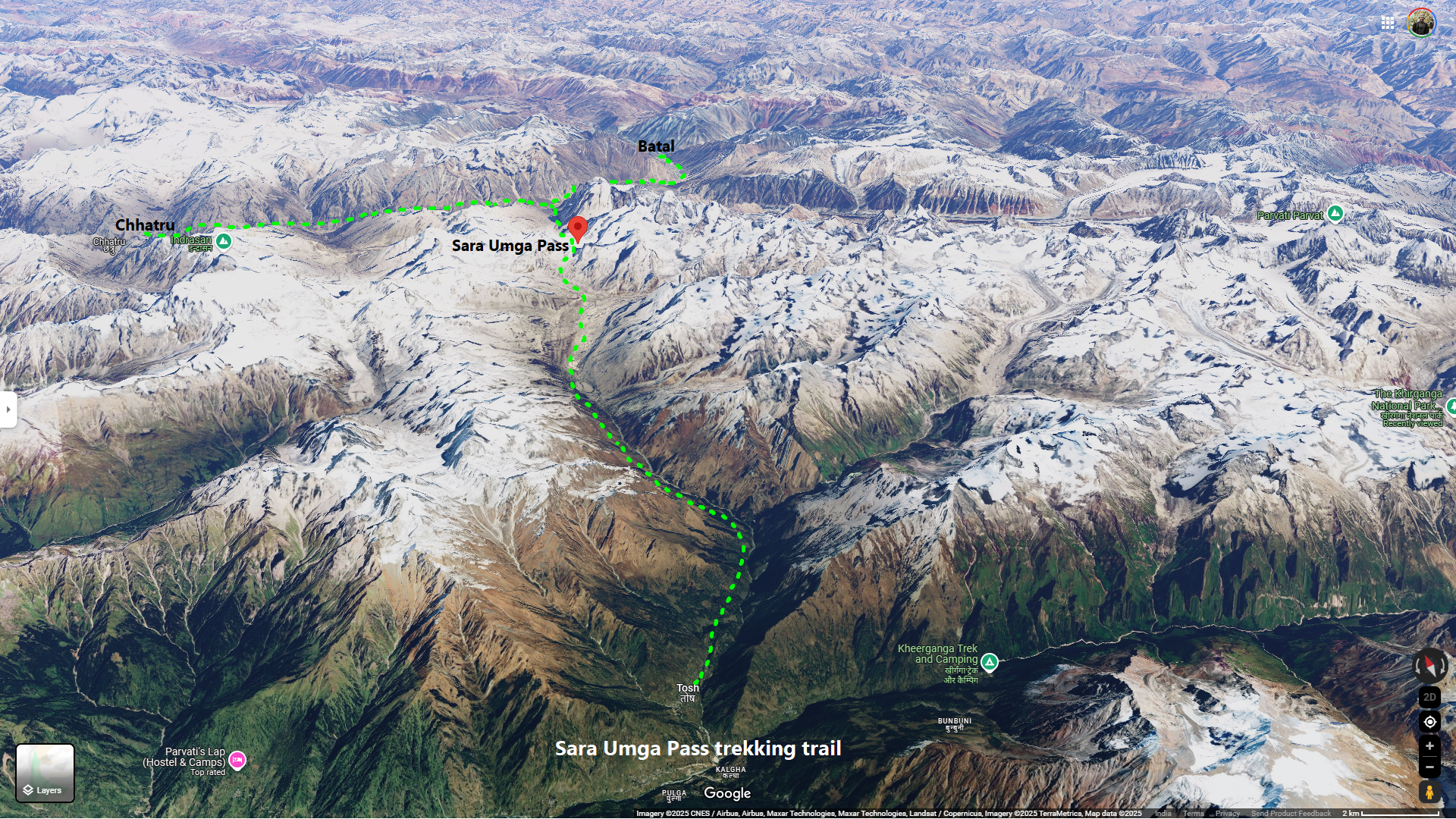
Sara Umga Pass Trek
Sara Umga Pass/La (32°12’13.7″N 77°30’49.3″E) approximately at ~ 5020 m, is a fairly difficult mountain pass and trekking trail in Himachal Pradesh. This pass connects the lush Parvati – Tosh river valley in Kullu region to that with the rugged Chandra valley in Lahaul.
The trek begins in the green meadows of Parvati Valley and ascends through glacial terrain before crossing the snow-laden pass, ultimately descending towards the Chandra River.
The Chhota Sigri and Sara Umga glacier is surrounded by the peaks like Snow Dome (5730 m), Shigrila (6041 m), Angdu Ri (5941 m), White Sail/Dharamsura (6250 m), Papsura (6451 m), Dewachand (6200 m), Lalana (6265 m).
From Bhuntar town, the road diverges from the Beas River and follows the Parvati River upstream. At Barshaini, take the route into the Tosh Valley, following the Tosh Nala, the main tributary of the Parvati River.
FACT SHEET:
Duration: Delhi to Delhi in 10 to 12 days. around 7 to 8 days of trekking.
Prerequisite: Prior high altitude trekking experiences on snow and ice is a must.
Location: Himachal Pradesh, Kullu and Lahaul-Spiti districts.
Grade: Difficult/Hard
Physicality: ~8.5/10
Trail Length: Approximately ~ 70 Km
Highest Point: Sara Umga Pass ~ 5020 m/16465 ft
Geo Coordinate: Sara Umga Pass 32° 12′ 13.7″ N 77° 30′ 49.3″ E (32.203806 77.513694)
Access: Reach New Delhi or Chandigarh and then take a bus to Bhuntar or Manali. From Manali or Bhuntar you will get a bus till Barshaini. From here Tosh village is some 6 to 7 km on a dirt road.
Seasons: June to mid September
Further Option: Can be combined with a side trip to Animal Pass and lake.
Nearest Rail station: Delhi/Chandigarh
Airport: Delhi or Chandigarh. Also there is an airport at Bhuntar, Kullu Airport (KUU), but with very limited options.
Suggested Day-wise Trek Itinerary
The motorble road reaches till Tosh village. It is often easy to arrange the trek logistics from Manali then at Bhuntar or Tosh.
Day 1: Tosh Village (2480 m) to Buddhaban (2850 m)
- Tosh has multiple well-arranged lodges/hotels.
- The initial path passes through farmland, followed by a steep ascent through a sparse forest.
- Kutla is the first significant stop with a small tea shop.
- After passing Kutla, the trail leads to a flat expanse in Buddhaban, a popular campsite used by shepherds.
Day 2: Buddhaban to Saram Thach (3480 m)
- The trail moves through grazing lands with scattered rocks.
- Encounters with shepherds are common.
- The path ascends and descends, passing through pine, birch, and rhododendron forests.
- After crossing Songre Nala, the trail reaches Saram Thach, a vast meadow surrounded by snowy peaks.
Day 3: Saram Thach to Samsi Thach (3850 m)
- The trail climbs through dense shrubs to a slope overlooking the Tosh Nala.
- The valley remains far below while the trek follows a high-altitude route.
- The trail involves crossing small streams and rocky terrain, gradually losing its greenery.
- After fording a knee-deep stream, trekkers arrive at Samshi Thach, a picturesque campsite with multiple small streams.
Day 4: Samsi Thach to Lake Camp (around Sara lake ~ 4320 m)
- A steep ascent leads to a nearly flat trail.
- En route, trekkers pass a rocky shelter used by local herders.
- Gradually, the Sara Umga pass region comes into view, featuring peaks like Dharamsura (6446m), Andurila, and Papsura (6451m).
- The trail crosses the turbulent Sara Nala, which splits into two branches and must be crossed with caution.
- The campsite is near a beautiful lake, surrounded by boulder-strewn ridges. The main Sara Lake is located at a higher altitude, requiring an extra day’s stay for exploration.
Day 5: Lake Camp to Base Camp (4680 m)
- The descent is steep and requires careful navigation over loose rocks and glacial debris.
- An alternate route allows trekkers to bypass Lake Camp and directly reach Base Camp, but this skips visiting Sara Lake.
- The trail follows the lateral moraine of Tosh Glacier, traversing rocky terrain with a risk of falling debris.
- The Base Camp area is a vast rocky zone with no clear path, requiring a map and guide for navigation.
- Tents need to be set up in a leveled rocky area.
Day 6: Base Camp to Sara Umga Pass (~5025 m) to Putiruni (3850 m)
- The trek starts before dawn, climbing alongside a small water stream.
- The ascent involves navigating ice-covered rocks and multiple crevasses, requiring roped crossing.
- The pass itself is a vast snowfield, barely distinguishable from the surrounding terrain, marked by a large rock.
- The descent follows the Chhota Shigri Glacier, passing multiple glacial tributaries.
- Roped crossings continue through crevasse-filled sections before transitioning to a well-defined path along the mountainside.
- The trek ends at Phutiruni campsite, which offers a clear view of the valley below.
Day 7: Putiruni to Batal or Chhatru (3360m)
- Phutiruni lies on the left bank of the Chandra River, with the road on the opposite side called Chhotadhara.
- There is no bridge at Chhotdhara (there is a risky Jhoola pul/rope bridge which may work seasonally) , so two options exist:
- Via Batal: Follow Chandra river upstream and cross the Karcha Nala – shorter and safer route
- Via Chhatru: Follow Chandra river downstream and cross the Deothach Nala – this trail may have moderately steep icy slopes directly going down into the roaring Chandra river.
- The trek follows a scenic route through alpine meadows before reaching the Deothach Nala, which is fast-flowing and requires rope assistance to cross.
- The final stretch passes through Chhatru Nala, which originates from Hampta Pass. This section has a bridge.
- A final river crossing over the Chandra River leads to Chhatru, which lies on the Manali-Batal-Kaza road, where buses and other vehicles are available for transport to Manali.
Additional Information
- Porters and Guides: Difficult to find on the route base at Tosh, but can be arranged from Manali
- Food & Supplies: Stock up at Bhuntar or Manali before the trek.
- Alternative Camp Plan: Instead of camping at Sara Lake, one can reach the Chhota Shigri Glacier’s edge and then move to Deothach Nala the next day, reaching Chhatru faster.
- Best Time to Trek: August to mid-September. May-June has heavy snow and requires advanced skills and equipment.


Comments