

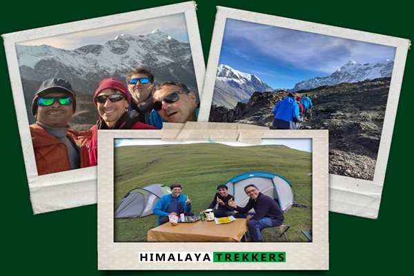
When Your Himalayan Trek Route Gets Blocked: How a Plan B Story unfolded in Uttarakhand
Three French scientists contacted us for a Pangarchulla Peak trek in late June . They are experienced alpinists who wanted to summit a proper Himalayan peak during their work stint in Bangalore. Visa delays pushed their trek from late June to September 7-13. We warned them back in June itself that September conditions had become unpredictable in recent years, although historically it’s been the post-monsoon clear season. They accepted the risk and went ahead with booking.
Forty-eight hours before their departure, the India Meteorological Department escalated alerts from yellow to orange to RED warning for Uttarakhand. Heavy overnight rain triggered multiple landslides blocking the Rishikesh-Joshimath highway. The state government stopped the entire Chardham Yatra, including the Badrinath and Hemkund Sahib routes that share the same road. Trek permits for Kuari Pass were unlikely to be issued. The Joshimath area itself sits on unstable hills, making it particularly vulnerable during heavy rain. Their Pangarchulla summit attempt was impossible.
We proposed Ali Bedni Bugyal trek as Plan B – different access route, better permit situation, homestay and fiber hut infrastructure for bad weather, and their guide’s home trail. They accepted immediately. The trek went ahead on schedule. According to their post-trek feedback, “Plan B turned out to be magnificent; it met all our expectations.” Here’s how that happened, and why having a proper Plan B matters more than ever as climate patterns shift in the Himalayas.
Trek Planning Summary: At a Glance
Original Trek Planned: Pangarchulla Peak with Kuari Pass
Crisis Event: RED weather warning 48 hours before departure
Plan B Executed: Ali Bedni Bugyal trek
Dates: September 7-13, 2025
Client Outcome: “Plan B turned out to be magnificent”
Client Profile
- Team Profile: 3 scientists, experienced alpinists from France
- Experience Level: High – regular mountain walking, alpinism background
- Original Trek Choice: Pangarchulla Peak (4,550m summit)
- Booking Timeline: Initial contact June 2024, visa delay shifted trek to September
The Crisis Timeline
June 2025 – Early Warning Signal
When the trek shifted from June to September due to visa issues, we flagged the risk: “September has historically been conducive for high altitude treks in Uttarakhand… although some residual rain is common. In the recent past there have been turbulences in September (mountain weather + climatic change has fuelled it).”
This wasn’t generic disclaimer language. We were documenting a real pattern – September used to be reliably post-monsoon clear, but recent years have shown increased weather instability.
September 4, 2025 (T-minus 48 hours)
Night of September 3-4: Heavy to very heavy rain starts across Uttarakhand
September 4 morning:
- Multiple landslides block Rishikesh-Joshimath highway at various points
- IMD escalates weather alert: Yellow to Orange to RED WARNING (statewide)
- Ground reports from local staff: Rain continuing, road blockages confirmed
- Spoke with trek guide Dev Singh at Srinagar: Rain since previous night, lesser intensity now but continuing
Government Action:
Uttarakhand government stopped all Chardham Yatra from September 5 until September 6. This includes Badrinath and Hemkund Sahib routes, which use the same road to Joshimath. This is not a routine precaution – it signals serious risk assessment by state authorities.
September 4 evening – Risk Assessment
Permit Situation:
Kuari Pass falls under Nanda Devi National Park. Permits require:
- Medical fitness certificate from Joshimath Government Hospital (obtained on-site)
- Not issued more than 48 hours in advance
- Forest and park authorities follow IMD 5-day alerts
With RED warning in effect and government stopping Chardham Yatra, permit approval was highly unlikely even if roads cleared.
Joshimath Vulnerability:
The basecamp area sits on geologically unstable hills. Road conditions deteriorate significantly during heavy rain. Even if permits were somehow issued, safety risk remained unacceptable.
Decision Point:
We reached out to clients proactively before they left Bangalore. The trek start was September 7 (Saturday). They were flying to Dehradun on September 6 evening. We had less than 48 hours to propose, discuss, and execute an alternative plan.
Plan B: Ali Bedni Bugyal Trek
Why This Trek Works When Kuari Pass Doesn’t
Geographic Location:
Ali Bedni Bugyal lies east of Joshimath, accessed via Lohajung (different road, different valley system). While both are in Chamoli district, the weather patterns and road conditions can vary significantly. The crisis was concentrated on the Rishikesh-Joshimath highway and the Joshimath area itself.
Permit System:
Not inside a national park boundary. Requires regular forest permits, which are:
- Less stringent process
- No mandatory medical certificate from specific hospital
- More flexible during borderline weather conditions
Infrastructure for Bad Weather:
- Homestay at Didna village (Day 2) – solid roof backup
- Forest fiber hut shelters at higher camps – weather protection if needed
- Established trail with multiple bailout points
Guide Advantage:
Dev Singh, their assigned guide, is from this region. Ali Bedni Bugyal is his home trail. This means:
- Intimate knowledge of local conditions
- Additional support network (family, local contacts)
- Better real-time decision-making capability
- Cultural access (later proved significant when he invited clients to his home)
Safety Assessment:
Given similar weather forecast for the week ahead, Ali Bedni offered safer terrain, better infrastructure backup, and more flexible permit situation. It was, in our assessment, “a safer option if similar conditions prevail for next 2 days.”
What They’d Still Experience
Altitude:
Up to 4,500m on the Roopkund trail section. While not a technical summit like Pangarchulla, this is serious altitude gain requiring acclimatisation.
Peak Views:
Rich mountain vistas including views of Trisul and the Nanda Ghunti range. Weather-dependent, as with any trek, but the potential is there.
Unique Features Not Available on Kuari Pass:
- Sprawling alpine meadows (the “Bugyal” that gives the trek its name)
- Monsoon wildflowers in full bloom
- Brahma Kamal flowers above the treeline on rocky sections
- Interior village stays with authentic cultural access
- Local Garhwali food in homestays
Cultural Depth:
This trek offered more village interaction than Kuari Pass. As it turned out, this became one of the highlights – the guide invited them to eat at his home with his wife and two young daughters, an experience they described as deeply touching.
Client Response
Robert’s reply came quickly: “Thank you for your efforts in arranging a Plan B. Yes, we would be grateful if your transporter could pick us up at the airport.”
No hesitation, no complaints about changing plans at the last minute, no demands for refunds. They trusted the assessment and moved forward. This is the relationship built through transparent communication from the first email onwards.
Logistics Execution (24 Hours Before Departure)
September 5-6 Coordination:
- Transporter arranged for Dehradun airport pickup (September 6, 18:00 arrival)
- Driver instructed to carry printed sign: “Robert Georges”
- Guide Dev Singh positioned at Srinagar (midpoint between Rishikesh and Lohajung)
- Plan: Dev intercepts the car, joins clients for journey to basecamp
- Sleeping bag arranged for Ludovic (he didn’t bring one)
- Storage confirmed for extra luggage at basecamp
- Trek logistics pivoted: Different route, different campsites, different support arrangements
Weather Update September 5:
“Good news is that it didn’t rain during daytime today.” Conditions improving but forecast still uncertain for the week ahead.
The Trek Outcome
Post-trek feedback from Robert, Samir and Ludovic:
On the Crisis Management:
“We wanted to undertake a high-altitude trek, but we were quite ignorant of the local weather conditions… We are very grateful for having crafted a Plan B for us despite the difficult monsoon conditions. This Plan B turned out to be magnificent; it met all our expectations.”
On Guide and Team:
“Our guide, Dev, demonstrated great professionalism and kindness. He was able to temper our eagerness and ensured we ascended at a slow enough pace for us to acclimatize gradually to the altitude… The logistics team was also great: the tents were set up, and tea and soup awaited us upon our arrival at the various campsites. We are not used to being treated so well in France!”
On Cultural Experience:
“We also appreciated visiting the different villages we passed through, the teas we had there, and our interactions with the locals. A special thanks as well to the aspiring guide for inviting us to eat in his home with his wife and two little daughters. We were very touched by this invitation.”
On the Trek Itself:
“We were delighted by the variety of scenery and atmospheres we encountered. The summit of Trisul is certainly beautiful, but we also loved the diversity of the landscapes: valleys, forests, waterfalls, snow-capped peaks… This trek was truly extraordinary.”
Final Assessment:
“Thank you, HT. I hope we have the opportunity to call on you in the future!”
Why This Matters: Climate Change and Himalayan Trekking
This isn’t just a story about good crisis management. It’s documentation of a larger pattern affecting Himalayan trekking.
September Used to Be Safe
Historically, September marked the end of monsoon season in Uttarakhand. By early September, you’d expect:
- Clearing skies
- Stable weather patterns
- Good visibility for mountain views
- Dry trails with minimal rain risk
This is why September-October has traditionally been considered the “shoulder season” – good conditions, fewer crowds than peak October.
Recent Years Show Different Pattern
We’ve documented increasing turbulence in September over the past several years:
- Extended monsoon tails
- Unpredictable heavy rain events
- Landslides during what should be stable weather
- Fog and cloud cover persisting longer
The 2024 September crisis wasn’t an isolated event. It’s part of a pattern we’ve been tracking and warning clients about since 2022.
What Trekkers Should Ask Operators
If you’re booking a Himalayan trek, especially during shoulder seasons or monsoon-adjacent months, these questions separate professional operators from budget vendors:
1. How do you monitor weather before the trek?
Look for: IMD data tracking, local staff reports, ground intelligence network. Not just “we check the forecast.”
2. Do you have viable Plan B routes identified in advance?
Key word: “viable.” Not just “we’ll figure something out.” Actual alternative routes with similar experience level, already scouted, permits understood.
3. What’s your ground intelligence network?
Can they get real-time updates from guides, staff, local contacts in the trek region? Or are they relying solely on internet weather forecasts?
4. What happens if permits are denied due to weather?
Refund only? Trek cancelled? Alternative offered? This should be in writing before you book.
5. How far in advance do you make the go/no-go decision?
Waiting until you reach basecamp is too late. The call should be made 48-72 hours before departure when alternatives are still possible.
The Cost of Poor Planning
Budget operators often can’t pivot. Here’s what happens:
- Trek cancelled at basecamp (you’ve already travelled)
- Partial refund offered (doesn’t cover your wasted flights, hotels, leave from work)
- No alternative route available (they don’t have the expertise or network)
- You return home having seen Rishikesh hotels, not Himalayan mountains
Plan B wasn’t just good service. It was the difference between “we had an extraordinary trek in difficult conditions” and “our Himalayan holiday was cancelled.”
What Makes a Good Plan B
Not all backup plans are equal. Based on this case and others, here’s what works:
Different Geographic Access:
The alternative route should not share the same bottleneck roads or vulnerable areas. Ali Bedni’s Lohajung access avoided the Joshimath crisis zone entirely.
Similar Experience Level:
Don’t downgrade from a summit trek to an easy valley walk. The clients wanted altitude and challenge – Plan B delivered 4,500m and alpine terrain.
Permit Flexibility:
Routes outside national park boundaries offer more permit flexibility during borderline weather. This isn’t about cutting corners – it’s about having options when conditions are uncertain.
Infrastructure for Bad Weather:
Homestays, fiber huts, or other solid-roof backup options matter when weather is already unstable. All-camping routes are riskier during uncertain conditions.
Guide Expertise on Alternative Route:
Your guide should know the Plan B trail intimately, not be learning it alongside you. Dev Singh’s local knowledge on Ali Bedni was a significant safety factor.
September 2025 Context: What We Know Now
The September 2025 weather event that triggered this Plan B wasn’t unique to that week. Uttarakhand saw extended monsoon impacts throughout September and into early October. Multiple treks were affected. Road blocks and landslides were reported on various routes.
Operators without flexible planning saw cancellations. Operators with robust Plan B options kept their clients trekking. The difference wasn’t luck – it was preparation and local intelligence networks.
Related Treks and Topics
- Pangarchulla Peak Trek with Kuari Pass
- Ali Bedni Bugyal Trek
- Roopkund Trek (shares trail with Ali Bedni)
- Climate Change and Weather Patterns in Uttarakhand
- September Trekking Conditions: What’s Changed
Below follows the complete email consultation showing how the crisis unfolded and Plan B was executed in real-time.
Part 1: Initial Planning for June and then Booking for September
We are three French scientists and we will be working in Bangalore in few weeks. We’d like to do a trek in the Indian mountains and we’re very interested in the Pangarchulla Peak trek that you’re proposing.
We’re both used to long walks in the mountains. I do myself a lot of alpinism in France.
We could be in Rishikesh on Saturday 21 June and we have to be back in Bangalore on Sunday 29 July.
Would you be prepared to organise this trek for us? Of course, we would be happy to be part of a larger group!All the best,
Greetings of the day from India . Thank you for reaching out to us, HIMALAYA TREKKERS (HT).
We are excited to hear your plan and will be more than happy to arrange a Pangarchulla peak trek for you and your team.
So here is our initial response based upon your inputs.
1) I understand you all are experienced hikers with fairly good fitness levels. This will be highly beneficial for the Pangarchulla summit day, as that is a very long and hard day of approx 12 hours from basecamp Khullara to summit and back.
Here is the trek details page for your reference:
Pangarchulla Peak with Kuari Pass
2) Late June is towards the end of the summer season, the trail will remain very green, maybe a few patches of snow at Pangarchulla top, if any. Expect some cloudy conditions or occasional rain which are common on the mountains.
3) As per the tour, it is unlikely that there will be a group departure that time. As per the custom tours, it’s definitely possible for 3 of you as per your preferred date to start. We can tweak the itinerary etc for this type of tours to accommodate more days or any other place etc that you may like to include in your planned tour.
It may be wise to keep an additional buffer day for trekking (weather and any other conditions), as you have approximately 7 days from Rishikesh to Rishikesh. We can keep the itinerary flexible as may fit best during the trek.
Please feel free to share any queries that you may have. I will send you an itinerary with a quotation based upon your any further inputs, e.g., any additional services you may need.
Best regards,
Thank you for agreeing to take care of us!
I’m sorry for my late reply. We’re having some problems getting our visas and we’re worried about getting them in time before our flight leaves. There’s still hope and we’re keeping our fingers crossed.
We’re definitely excited by the idea of reaching the summit of Pangarchulla, weather permitting, of course.
We all have our own equipment for trekking at altitude: warm sleeping bag, hiking poles, warm clothes, gloves, etc.
We have a few questions for you:
– do we need to bring our own trekking tent to India?
– do we need mountaineering boots (with rigid soles for crampons) or are trekking boots enough?
– Do we need to provide food for several days or is it supplied by you (which would make life easier for us)?
– What is the nearest airport to Rishikesh (we will be arriving from Bangalore)?
As specified in the trek details, we will need a pickup from Rishikesh to Joshimat.
Could you send us a quotation for this nice trek?
I’ll let you know as soon as we hear from the Indian embassy about our visas…
Greetings of the day. Thank you very much for your detailed response. Hope that you will get your visas just in time. .
In India an organised trek is like taking care of every logistics that may be required for a given trek. It includes stay/accommodation, camping equipment/gears (tents, sleeping bags and mattresses, kitchen and toilet tent etc) all cooked meals and for that provisions/ration, utensils, fuel, gas cylinder/burners/stoves etc, an experienced local guide, cook and any support staff/porter/packed animals to carry the entire logistics.
So it’s quite a bit of logistics, initially a heavy one given a trek is camping style in nature. You just need to bring your personal gears or any equipment and you already have those as you have mentioned. We do provide sleeping bags as well, although it is always better to use your personal sleeping bag for hygiene and comfort.
Are you looking for an organised trek? Or rather prefer an assisted DIY style where we take care of all permits, necessary paperworks, provide a guide and some other logistics that may be required?
Please find answers to your questions:
– do we need to bring our own trekking tent to India?
No you don’t if you prefer an organised trek. We can provide a triple sharing or single supplement tent if need be.
– do we need mountaineering boots (with rigid soles for crampons) or are trekking boots enough?
Yes, sturdy waterproof trekking boots/shoes are fine for Pangarchulla summit in summer. A good rubber soles and ankle support are a must as you need to hop on boulders to the summit during this time.You need not carry your mountaineering crampon adjustable boots.
– Do we need to provide food for several days or is it supplied by you (which would make life easier for us)?
We will take care of all cooked meals (B,L,D in short) and anything required to do so.
– What is the nearest airport to Rishikesh (we will be arriving from Bangalore)?
Dehradun (Code: DED) is the nearest airport from Rishikesh, and approximately an hour’s drive (~20km). You get a few daily direct flights from Bangalore. We will arrange a pickup from Rishikesh to basecamp and return, along with any airport taxi transfers, if that makes things hassle free.
Let us know whether you prefer an organised trek or anything else? I will revert with a quotation accordingly.
Also feel free to ask any more questions or anything that you may like to share or need any assistance.
First of all, I’d like to thank you for your detailed answers to my questions.
We were waiting for our visa applications before coming back to you. Unfortunately, our visa was refused by the Indian embassy because we had applied for an affair visa instead of a “scientific” visa. It is too late to submit a new application. Samir, Ludovic and I have therefore decided to postpone our trip to Indian until September.
We’d still love to visit the Himalayas under your assistance. Would you be willing to organise the Pangarchulla trek for us between 7 and 13 September?
I’m really sorry for the inconvenience.
Good morning and great to hear from you. Thank you for getting back to us. We completely understand the situation.
Also I am sorry that replying late, took a bit of liberty that your tour is postponed! At the same time, we would love to organise the Pangarchulla trek for your team in the first half of September.
On the new season/date note that September has historically been conducive for high altitude treks in Uttarakhand and other parts of western Himalayas.. It’s essentially the end of monsoon season, although some residual rain is common. In the recent past there have been turbulences in September (mountain weather + climatic change has fuelled it). We hope that the monsoon will end by time and you will get very green and clear post monsoon weather as this year monsoon is more or less “normal”, arriving on time – and up to 10 days delay as we write here in Kolkata. ✌.
Expect typical boulder hopping as there will be no snow left during the first half of September to Pangarchulla summit.
Suggested itinerary for Pangarchulla with Kuari pass trek:
Day 1 (7th Sep): Drive from Rishikesh (start by 6 to 7 am) to Joshimath (1875 m/6150 ft) – ~10 hours – 260 km. Lodge accommodation.
Day 2: All trekkers at present need to visit Joshimath hospital to get a fitness certificate to obtain the trek permit before the trek. Check notes below. Drive to Karchi village (7500 ft) via Dhak – 15 km, 45 minutes. Then trek to Khullara (3385m/11,100 ft) – 11 km, 5 to 6 hours. Camp.
Day 3: Visit Kuari Pass (3850m/12630 ft) and return to Khullara – 8 km- 4 to 6 hours. Also works as an acclimatisation day before the summit. Camp.
Day 4: Khullara to Pangarchulla summit (4550m/14,925 ft), 6 hours and back to Khullara – total 12 Km – approx 12 hours. A strenuous and challenging summit day. Camp
Day 5: Khullara (11,100 ft) to Auli (2620m/8600 ft) via Gurson Bugyal, 5/6 hours – 10 km – drive to Joshimath 45 mins/14 Km. Lodge accommodation.
Day 6 (12th Sep): Extra day on the mountains/camping – We will utilise this day on the mountains as per prevalent conditions (backup day for summit or as a warm up/acclimatisation day at Upper Gulling etc.)
Day 7: (13th Sep) Drive from Joshimath to Rishikesh – 260 km – 9 to 10 hours.
For route details, difficulties, photos, and other useful information check the below link:
https://dev.himalayatrekker.com/tours/pangarchulla-peak-trek-with-kuari-pass/
Important Notes:
- Medical Fitness certificate to be obtained from Joshimath Hospital: Starting from this summer Joshimath Administrative officials have made it mandatory to visit Govt. hospital and get a basic medical test/physical checkup there on spot. This may take some time depending and has some time dependency. Either on Day 1 after noon or Day 2 morning we need to complete this.
Often it is convenient to reach Rishikesh anytime on Day 0. Either you can fly to Dehradun (DED, Jolly Grant airport) which is only 1 hour drive from Rishikesh. or you can get Volvo services (morning and overnight) from ISBT Kashmiri Gate Delhi to Rishikesh (5/6 hours). Arrange your stay in Rishikesh accordingly. - You are free to reach basecamp independently. Cab fare is approx ₹ 7500 – 8000 for a Tata Sumo / similar, one way.
- ATM: Last ATM at Joshimath but may get out of cash. Withdraw well in advance, either from Rishikesh, Srinagar, Gauchar, or Karnaprayag.
- Mobile connectivity: All major networks work at basecamp Joshimath. After that you may get an intermittent network or not at all till you reach the endpoint Auli.
Does the above itinerary look good to you all? If so, we would need one detail from you about your accommodation preferences. For 2 nights hotel/lodge stay and 4 nights of camping. Do you prefer a triple sharing or 2+1 or 1+1+1 type? Anything else you would like to mention here?
Do feel free to revert with all your queries before we proceed.
Thank you for all these details. Your itinerary looks good to us. A triple sharing accommodation is fine; we’ll adapt to what’s available in any case.
We will keep you informed of the progress of our visa application.
Part 2: The Weather Crisis (around 5 days before departure)
Good evening and hope all is well with you and set for the trek.
We would like to share one latest development that has become somewhat of a somewhat concern lately. Since yesterday night it’s been raining heavily to very heavy in Uttarakhand as we spoke with our local staff in different parts of the state. This triggered a series of landslides on the way to Joshimath and roads are blocked on various places along the highway as of now.
As we have been following weather from IMD since last weekend, today they have updated the alert level a full grade up from yesterday, yellow became orange and today they have issued a red warning statewide. Here is a snapshot of the latest update from IMD Dehradun centre.
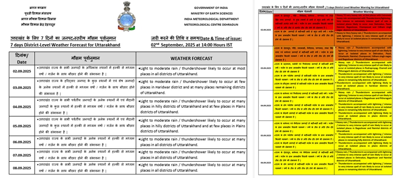
Although the attached extended range forecast has better predictions for the coming days, we probably need to be prepared for moderate rain and foggy conditions on mountains. I just spoke with Dev Singh again now, rain is continuing that started last night, albeit now in lesser intensity.
As a matter of fact due to the above warning Uttarakhand govt has stopped all Chardham Yatra, including Badrinath/Hemkund Sahib (close to Joshimath and same road) from today and until 6th of Sep. Trek permits are usually given not more than 48 hours in advance, and in this case along with a medical certificate. The forest and national park authorities would go with the 5 day alert as per my opinion.
Roads are a real concern and we will closely observe how things move in the next 24 hours. If the conditions improve in the next 48 hours including road etc plus a better forecast for the trek, then Kuari Pass seems good to go. Else we may have to figure out a Plan B so that your mountain holidays remain intact. Within Uttarakhand route conditions will remain broadly similar with some hassle to reach basecamp including some manual transfers over a road blockage and taking another car forward. If the situation arises your guide will accompany you in the base camp journey.
If you have not booked a Rishikesh stay yet, book just before the trip. There are a lot of decent standard options.
I am available over Phone and WhatsApp for any assistance or discussions.
Next Update:
So here is the update till now (just now finished talking with your trekking guide)
1) Today’s daytime rain was very less but there were fully cloudy conditions throughout. Chances of rain in the night.
2) Road block continues although we hope it will improve by the 7th!
3) Kuari Pass basecamp Joshimath area is itself very vulnerable/unstable hills and roads are in worse condition during these heavy rains. Additionally its permit process is more stringent as it falls under Nanda Devi National Park area including medical certificates etc, and as rain forecast is there for next week also, so they may deny permit at last moment on 7th or 8th morning.
So we propose a Plan B, in an area closer to Kuari Pass towards its east and called Ali Bedni Bugyal trek that is not inside a national park area and requires regular forest permits. The trail covers sprawling alpine meadows that are particularly green with monsoon season flowers. We can make use of the homestay at Didna village and forest fibre hut shelters in higher up, if conditions demand. Peak view wise this trail is also very rich, but that will depend upon weather conditions. Culturally this trail provides more insights compared to Kuari Pass as here we have real interior village stays, tasting local food and getting a closer look at the himalayan culture. Heightwise here also we can do some serious gain, upto 4500 m on the Roopkund trail, and witness Brahma Kamal flowers that bloom above the alpine meadows on rocky areas.
An additional advantage of this trek is that the trail is home to your trek guide Dev Singh and any additional assistance for transport or anything during trek and is a safer option in our opinion if the similar conditions prevail for next 2 days. We will watch.
Rest arrangements including 2 tents are noted. We are in touch with the transporter for the pick up and drop. Do we ask him to arrange one from Dehradun airport to Rishikesh on 6th evening? If yes, time?
We hope that given the unfavourable weather in the Himalayas, we will still be able to arrange a meaningful safe holiday 🙂
Cheers,
Thank you for your efforts in arranging a Plan B.
Yes, we would be grateful if your transporter could pick us up at the airport and take us to Rishikesh. Our arrival time at Dehradun is saturday 06 Sept 18:00 (6:00 pm).
Cheers,
Part 3: Executing Plan B
Your arrival and departure times are noted. We will arrange airport transfers accordingly. Also it is very good that you have a day at the end, just in case there are some delays etc.
As per the weather update, today, day time rain was very light/overcast, although yesterday night it rained moderately heavy. As road conditions worsened on the Joshimath side, I think it is best to stick to Plan B from now on.
I will keep you posted and share taxi details etc tomorrow evening.
I just wanted to let you know that one of us doesn’t have a sleeping bag, but Robert and I have one. Robert wants to know if it’s worth taking it.
Is it possible to leave a change of clothes somewhere before setting off on a hike and pick them up afterwards?
A good news is that it didn’t rain during daytime today. Hoping further improvements on the weather!
You all may leave your additional luggage at basecamp Lohajung and collect it after the trek. It’s better to carry your personal sleeping bags. We will provide one for Jean.
Transporter has arranged the airport pickup for tomorrow. I will share the contact details of the driver tomorrow. Meantime I have asked the driver to carry a printed paper written your names. He will be at the main exit of the airport (it’s a small airport)
Post-Trek Feedback
We wanted to undertake a high-altitude trek, but we were quite ignorant of the local weather conditions and we didn’t have enough time to organize all the necessary logistics ourselves (transportation, food, etc.), which is why we contacted Himalaya Trekkers.
Our first point of contact with HT was very encouraging. Your quick responsiveness and complete transparency regarding the organization and pricing immediately inspired confidence in us.
We are very grateful for having crafted a Plan B for us despite the difficult monsoon conditions. This Plan B turned out to be magnificent; it met all our expectations.
We were taken care of by an extraordinary team. Our guide, Dev, demonstrated great professionalism and kindness. He was able to temper our eagerness and ensured we ascended at a slow enough pace for us to acclimatize gradually to the altitude. The food was excellent and very varied. We extend a warm thank you to the chef. The logistics team was also great: the tents were set up, and tea and soup awaited us upon our arrival at the various campsites. We are not used to being treated so well in France!
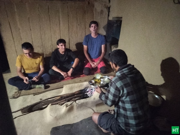
We also appreciated visiting the different villages we passed through, the teas we had there, and our interactions with the locals. A special thanks as well to the aspiring guide for inviting us to eat in his home with his wife and two little daughters. We were very touched by this invitation.
As for the trek, we were delighted by the variety of scenery and atmospheres we encountered. The summit of Trisul is certainly beautiful, but we also loved the diversity of the landscapes: valleys, forests, waterfalls, snow-capped peaks… This trek was truly extraordinary. Thank you, HT. I hope we have the opportunity to call on you in the future!
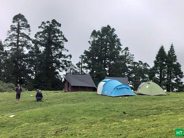
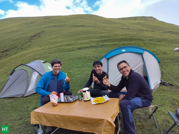
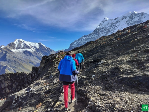
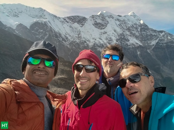
Some photos from the trek:
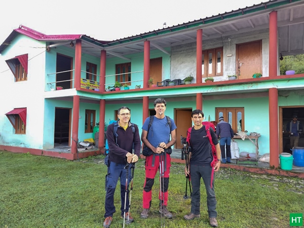
Let’s connect and plan your next trekknig vacation in the Himalayas!



Comments