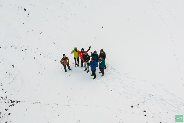
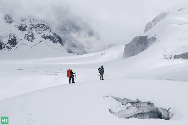
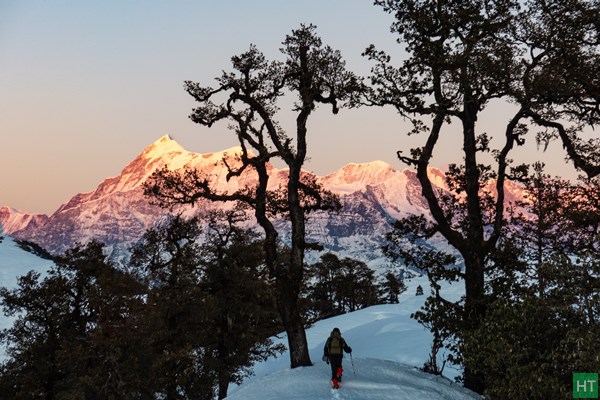
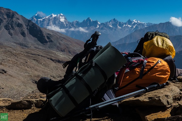
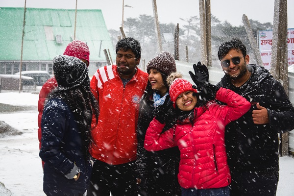
Prelude: We geared up for a winter trek knowing that we will get much more snow than we would like to. Slogging into knee deep snow was inevitable as we got information beforehand. So we prepared for a challenging White Christmas.

There are quite a few trekking trails in Garhwal to explore and no wonder that Brahmatal trek is probably in your bucket list. The splendid walk to the sacred lake of Lord Brahma fame serves primarily as a classic winter trek. Entire trail commands some of the finest views of the snow capped peaks of the outer wall of Nanda Devi Sanctuary.

Lying almost within a tree line this short trail seems to be a beginner’s delight. According to a local legend lord Brahma once meditated on the shores of this lake and hence its name. Lohajung (7500 ft) serves as the base for this trek, a cluster of shops and guest houses, usually like a Bazar in hilly areas.

Our plan was to trek and celebrate a possible “White Christmas” on the mountains. During mid of December we came to know about a heavy snowfall in the area from our trek guide. In fact it was so intense that it snowed as low as 4000 ft height. Even though Brahmatal seemed quite difficult to reach, our guide assured his best. Also he said he will adjust the itinerary so that we can spend maximum time on the mountains. So we started from Kolkata, aware of the fact that Lohajung has more than a foot of snow at present. Yes, more than a week after the snowfall!

Do check Brahmatal trek details page for standard itinerary and related tour package by HT.

So, expecting a rough time ahead, we  boarded Lalkuan Express from Kolkata. Despite some fog it reached Lalkuan the next day in around 24 hours. 4 of us, Soumik, Abhirup, Saptarshi and myself Sourav. We quickly checked into a budget lodge beside the railway station to keep things simple. The winter of late December had pulled a curtain of fog over entire northern India, and so as Lal Kuan. We pre booked our seats in a shared vehicle through a local transporter which was supposed to take us till Deval the next day. From Deval we should get another shared vehicle or else to reserve a car to Lohajung, around 25 Km. There is not much to do at Lalkuan. In the afternoon we took a short walk. The room had a tv and we enjoyed ATK winning the ISL that evening.

Day 1: Lalkuan to Lohajung via Deval

We woke up early at around 5:30 and by 7:00 we checked out from the lodge. Shared car had arrived and we hurriedly finished our breakfast of puri and subzi to start our jounrey. However reports ofheavy snowfall were already flowing in and we came to know that the road to Lohajung was cleared for traffic only last evening. Several electric poles were brought down by the snow and our trek base was without power.

In half an hour we passed Kathgodam to find the gloomy mist is no more. Above us was the deep blue sky of December with never ending ridge lines ahead. Our journey was now to continue through Kumaon Himalaya up to Gwaldam along some of the finest hill stations of Almora and Kausani. On both sides of the road forests of Pine trees stretched for miles, with their needle shaped dry leaves adding a shade of brown on the forest floor. We made a couple of halts for tea and lunch. At Gwalam we experienced heavy snow on the road. The road was cleared but heaps of snow was lying on both sides. There was knee deep snow around every house.

peak-views-from-gwaldam
Peaks from Gwaldam
snow-covered-gwaldam-town
Heavy snow on road at Gwaldam

From here we entered Garhwal Administrative Division. From Tharali our journey continued along Pindar, one of Alakananda’s loveliest tributaries. We reached Deval, around 5 pm and changed to another jeep for Lohajung. It was dark in the winters when we arrived at Lohajung around 7:00 in the evening. The last stretch from Deval to Lohajung is a continuous upward climb and has considerable height gain.

At Lohajung our guide Mr. Dev Singh Ji greeted us and we checked into the lodge. Soon Dev Ji called a meeting to discuss the plans for the next five days. This year Garhwal experienced its heaviest snow in the last 40 years. The trails through the forests over the ridges were knee deep snow and there was even more snow at Bramha Tal. Under such conditions we had to break from our scheduled itinerary.

Our initial plan was a 5 days round trek to Brahma Tal from Lohajung, while doing a round trip to return to Lohajung via Wan village. It was decided that the team will head for Azan top the next day and return to Lohajung by afternoon. This is a top of the ridge on which Lohajung lies as if a pass. This will help the members to have a first hand experience of walking through knee deep fresh snow. We will then head for Bramha Tal the next day and proceed as far as we can. If we return to Lohajung in a couple of days then we can also trek to Didna village and enjoy the local home stay. So the plan was pretty good, making the best out of the given conditions.

Day 2: Lohajung to Azan top and back

At 8:00 in the morning we were ready. There was no need to carry our rucksacks today. So we went to Balbir Singh Patwal’s restaurant for breakfast. After Breakfast we put on gaiter with our guide’s assistance as we all were new to this equipment. None of us had the experience of going through such heavy snow and as such the team was excited. Azan top is around 750 feet above Lohajung –a hilltop overlooking the village. We traced back the motorable road and started to climb over a gentle path to our left. We passed through several village huts but as we climbed higher the snow on the trail deepened.

snow-at-lohajung
Still slushy snow at Lohajung

We were getting a good grip with our feet going down in the soft snow. After around 30 mins we crossed the telephone tower (visible from Lohajung) and started to move further. From here the trail is rather steep. By now we had left the village huts behind and scattered over the ridge were Birch trees bushes of Rhododendron with their base under heavy snow. Occasionally we stopped to take snaps.   We crossed a couple of snow fields to reach the top.

ajan-top-lohajung
Ajan top ahead

The hill top is marked by a temple dedicated to lord Shiva. Our trekbase could be seen down below the ridge. The terraced fields of Didna Villagewere clearly visible on the opposite side of the ridge. The ridge top was a large area and behind the temple it extended for about another 400 feet before descending to the opposite side. On a clear day the views of Nanda Ghunti,Trishul and Mrigthuni are breathtaking from here. We took several snaps and spent almost an hour at the top.

climb-to-ajan-top-lohajung
Already heavy snow just around Lohajung
ajantop-beside-lohajung-full-with-snow
Snow snow everywhere @ Ajan top

Dev advised us to take a shortcut on our way down and it was a real fun to run down the steep snow covered slope. We reached Lohajung around 2:00 in the afternoon and had lunch. We strolled in the small bazaar area and witnessed a magnificent sunset in the evening.

sunset-from-lohajung
Mesmerizing colours changing fast during sunset

Day 3: Lohajung to Bramhatal Base

We woke up early and soon began to get ready.  Already packed our rucksacks the previous night making sure to carry only the items we really needed and left back any additional luggage in our base. We finished our breakfast of roti and sabzi followed by a cup of tea and hit the trail.

For the first couple of kilometers the trail was free of snow and Dev advised us not to fasten out gaiters. The trail gradually began to climb on the ridge above the village and we went past a few village huts.  There is a pipe line along the trail feeding water to Lohajung. We turned back after a couple of hours and could see snow covered Azan top shining in the morning sun.

looking-back-towards-lohajung
Looking back towards Lohajung and Azan top

Towards our right and on the lower slopes lay the picturesque village of Mundoli. The slope of the hill leading to Azan Top ended in a few huts leading to Lohajung. Looking towards south the endless ridgelines could be seen gradually rising above another and fading away in the midday haze near the horizon. We took a break here to recharge ourselves. The ridge in front of us was heavily forested and Dev pointed to a depression between two spurs on the ridge top which was to serve as the final destination for the day.

rest-on-the-way
A rest on the way

Now we entered the forests of Oak and Deodar and with the sunlight shielded by the foliage the snow on the trail began to increase. Occasionally we crossed a short stream of running water taking care not to wet our shoes. After another hour’s trek Dev advised us to fasten our gaiters. From here we moved to our right and began to climb up the snow covered trail. We trekked for another 45 minutes or so to our front and slightly below the ridge we noticed what appeared to be dense fog accumulated.

entering-into-snow-trail
Snow walking inside forest

This part of the trail was covered under thick canopy of the forest and after approaching another fifty yards and on a closer examination we found the ridge covered under a very thick blanket of snow. It seemed this place never received sunlight and on approaching we could feel the difference in temperature. Even at midday it seemed to be evening here and the snow was soft and powdery. We paused and the entire team took snaps and then moved further on.

cold-stretch-of-forest
Unusually cold during midday

The trail took a turn to the right and started to move up traversing the ridge. This dark and desolate place continued for almost eight hundred meters and finally we could see sunlight much to our relief. We finished the climb to the ridge top and in front of us flooded in the afternoon sun was the small lake of Khopdaliya.

khopdaliya-lake
A small frozen lake at Khopdaliya

One after another all members in our party arrived and assembled under a tree which was the only place devoid of snow. We took off our rucksacks and sat down comfortably giving ourselves much needed rest and took some refreshments. The ridge top was lined with rows of Pine and Deodar with a depression in the center forming the small lake. We had planned to camp here for the night but it being only past midday we decided to move further and camp near the bugyals from where the peaks would be visible.

The path from here began to rise gently and after another 10 minutes a large lake opened onto our right. Hidden mostly from sight by birch and rhododendron trees was the beautiful lake of Bekhal Taal frozen completely in the winter of late December. Approaching the lake from this side was difficult and needed goingdown a very steep incline over snow. The temple dedicated to Bekhal Nag Devta was visible on the opposite side and we decided to visit the temple and lake on our return.

hidden-fully-frozen-bekhal-tal
Bekhal Tal hidden inside forest

We started to move up towards the ridge top and what appeared to be a gentle climb became very steep towards the end. The arduous climb ended atthe edge of the bugyal some 750 feet above Bekhal Taal. There was a very thick cover of snow on the ridge top and above us lay rolling snow fields stretching for miles. However all the hardships paid off on looking to our right. The magnificent massif of Trishul and Mrigthuni were standing tall, their slopes shining brilliantly in the afternoon sun.

climb-above-bekhal-tal
Climb becomes steep on heavy snow
trishul-and-mrigthuni-peaks
First views of peak panorama

We crossed the first snow field and descended over a spur when our guide informed us that we will have to abandon our plans of camping here as there was no dry wood available for lighting a much needed fire. The only option was to keep moving ahead and look for a place to camp near the woods.  Exhausted, we helped ourselves to a rock and frantically searched the pockets of the rucksack for any dry food that may be available. Refreshed, we again set off for the final leg of our journey. We continued over the bugyals for a little more than an hour and it was now time for the sun to set.

walking-on-snow-field
Walking on snowfield continues
more-snow
Nandaghunti massif before sunset

We increased our pace on the snow and after a while took a turn to the right and started descending down the slope to our camp. This last stretch over the steep snow covered slope was made with extreme difficulty,carefully negotiating the rhododendron bushes under very low light. It was darkand extremely cold when we reached camp.

sun-down
Magenta during sunset
snow-snow-everywhere
More colours on the other side

Our tents were already pitched on snowand I took off my rucksack and hurried towards the lifeline – fire set up by our support staff. The next few hours were spent sipping hot coffee andenjoying the warmth and drying our shoes and socks which were dripping wet. We were served with hot Khichdi, scrambled eggs and pickles for dinner and finally crashed in the comfort of sleeping bags. End to a very tiring and indeed an eventful day.

Day 4: To Bramha Taal and back to Lohajung

We woke up to a bright and sunny morning and began to get ready. Our plan was to climb up to the bugyal top further ahead from where the peaks were visible and then trek back to Lohajung by evening. Soon hot maggie was served and we packed our rucksacks. The support staff was to pack camp and meet with us on the top.

our-campsite
Our unexpected campsite @ Telandi

Accompanied by our guide we hit the trail. We skipped to visit the lake, i.e. Brahmatal which is hidden on the opposite side of the ridge. The lake is fully frozen and there is no mountain views from the lake site, as the ridge stands as a natural barrier to the snowy peak views. After climbing to the top of the ridge we turned left and began to climb over the snow covered bugyal slopes.

Our aim is to reach Jhandi Dhar or Jhandi Top, a vantage point from where we could get a breathtaking view of the snow mountains. The vast undulating surface stretched for about 2 kms. The sky was clear and a vast panorama of peaks began to unfold in front of us. The trident of lord Shiva and the veil of his consort were shining brilliantly in the morning sun. The last hundred feet or so was over almost flat ground under knee deep snow cover and we assembled one after another.

climb-up-from-campsite
Climp up to the ridge above the camp

In front of us and from left to right were the peaks of Nanda Ghunti (6309 m/20,699 ft), Bethartoli Himal (6352m/20841ft), Trishul (7120m/23709ft), and Mrigthuni (6855m/22827 ft). On top of the ridge in front of us lay the twin bugyals of Ali and Bedini now under heavy snow with the famed Roopkund area above them. The sky was so clear that we could also see Ronti Saddle and Ronti Peak in the distance. We stayed on the top for around 40 minutes and took several snaps and finally it was time to retrace our steps back to Lohajung on the now familiar route.

reaching-jhandi-dhar-brahmatal-trek
Reaching the viewpoint called Jhandi Dhar/Top
jhandi-dhar-top-brahmatal
Team HT
ht-support-staff-the-best-in-class
When the going gets tough, the tough get going

Descending was much easier, not tiring and within an hour we hit the tree line. It was then a downward march to the temple of Bekhal Nag through the forests of oak and rhododendron. We slipped occasionally over the roots and fallen trunks hidden under the snow. After another 40 minutes the lake came into view and we turned left and began to traverse the slope to the temple. The frozen lake that was hidden from view on our way up now came into full view from here. Our support staff had already arrived and we had an early lunch.

bekhal-nag-temple-beside-bekhal-tal-lake
Bekhal Nag Temple
bekhal-tal-fully-frozen-in-december
Fully frozen Bekhal Tal

After a break of an hour we again started for the final leg of our journey. From here we turned left and descended to the bed of a ravine and began to climb the slope on the opposite side. Our plan was to traverse this slope and reach Khopdaliya on the other side of the ridge. This ridge received very little sun and was under very heavy snow cover. There were rhododendron trees scattered over the ridge and we took the help of its branches pulling ourselves from the knee deep snow as we proceeded along. About a couple of km before Lohajung there are bifurcations on the trail with the lower path leading to Mundoli village. One should take care to be on the trail that goes above the ridge.

inside-snowy-rhododendron-forest
Inside Rhododendron forest
inside-the-ravine
Crossing the ravine

The sun was about to set when we came across a vantage point some 500 ft above Lohajung. Here Nanda Ghunti stood giant at the backdrop of Didna village, which we plan to visit tomorrow. We witnessed a grand sunset on Nanda Ghunti. Finally we reached Lohajung around 6 o’clock in the evening.

valley-view
Valley side view while descending the last stretch
sunset-on-nandaghunti-peak-above-didna-village
Sunset on Nanda Ghunti, below is snow filled Didna village

Day 5: Lohajung to Didna village

Our destination for today is the picturesque village of Didna on the ridge opposite to Lohajung. From our lodge in Lohajung we have gazed at its snow covered terraced fields and the magnificent massif Nandaghunti that rose behind this village. The twin villages of Didna and Kulling are on opposite sides of each other on two ridges with the Neel Ganga River cutting a deep gorge in between. Today’s trek consisted of a splendid walk between these two villages and a chance to experience the simple life and enjoy the hospitality of peace loving villagers.

We started our journey late at about 9:30 after breakfast. For the first 6 Km the journey is along the motorable road that leads to Wan. We took a lift in a passing vehicle that shortened our journey. To our right the deep gorge of Neel Ganga opened up, its slopes lined with thick forests with endless ridge lines descending to the valley below. We reached Kulling Village and left the motorable road and followed the village track towards the bed of Neel Ganga. This track initially passes through the village huts and further down goes past terraced fields. Kulling serves as the winter home for the residents of Didna and is now full to its capacity. Almost every village home had stacks of hay piled up as fodder for cattle.

kuling-and-didna-village-with-trishul-peak-between
Kuling and Didna village on the opposite side of the valley
kulling-village
Kids doing homework during winter vacation at Kulling village

We passed the terraced fields of freshly sown wheat and descended to the bed of Neel Ganga River. Near the river there was a small wheat grinding unit powered by the flow of water running down a side stream. Its called Pan Chakki in local/Hindi language. The descent was almost eight hundred feet and took us almost an hour. Here we took a break and some refreshments to prepare ourselves for the moderately steep climb to Didna. The trail after crossing the river over an iron bridge begins to climb up the ridge in a series of short and steep turns. The steep uphill trek continued for another two hours involving a height gain of twelve hundred feet. We reached Didna village at around 2:00 in the afternoon.

reaching-didna-village
We reached Didna
inside-kitchen
Inside our homestay kitchen

Didna is a well spread out village on the ridge that leads to the famous Ali bugyal. The villagers are essentially a farming community andgrow wheat, barley and potatoes. After lunch we set out to have a walk in thislovely village passing through the village huts and fields of freshly sownwheat. We witnessed a grand sunset with the sky turning golden yellow, magenta and finally fiery red. We reached our Homestay by 6 and darkness of the night approached the quaint landscape.

sunset-from-didna-village
Sunset time

We got hot soup while the support team soon started piling heaps of dry wood on the open courtyard. It was 25th Dec and preparations were on for the Christmas party. Soon the entire team clustered around the fire, its warmth giving us much needed relief from the extreme cold. Our party continued till late night and finally we had our dinner and crashed into the comfort of bed.

bonfire-celebration
Party time

Day 6: Didna to Lohajung

It was almost 8’o o’clock in the morning when we woke up. We knew that the viullage starts getting direct sunlight a bit late. For this reason usually it is very cold during winter mornings. The two thousand five hundred feet high ridge overlooking Didna village blocks the sun as well as the peaks of the sanctuary. However nature was already up and the birds of the Himalaya were singing and dancing in the foliage around us. I took my camera and went out to have a stroll around our home stay.

white-collared-blackbird
White-collared Blackbird

The village’s homes are mainly built with stone,their walls plastered with mud. Thin slabs of slate are used for the roof work. There was a wealth of bird life around – White collared blackbird, Himalayan bulbul, Streaked laughing thrush, Babblers and Magpies to name a few. We had an early lunch and by 1o o’clock we were ready, our rucksacks packed and started on the descending trail to the bed of Neel Ganga and finally to the road head at Kulling. We took a pre reserved car to reach Lohajung before by early evening.

didna-village
Didna basking in the sun

Day 7: Lohajung to Haridwar

Our happy days of roaming in the mountain wilderness were now coming to an end. We packed our rucksacks, bid farewell to our guide and other staff with whom we stayed like a family. So we boarded a jeep and began the long descent to Haridwar. Soon I will be back to the busy city life but the memories gained in these few days will remain etched in my mind forever.

All photos are shared by Sourav and Saptarshi.

We would be more than happy to help you with any travel or tour related enquiries. We are available over email, phone and WhatsApp. Mon to Sat: 10 am to 8 pm.

9836133166/9831112469
Share this:

When deciding on a destination, I usually choose a theme and try to capture the basic essence of the trip. The biggest goal of winter trip to India during early January of 2019 was trekking in the Himalayas. Because of the strength it requires and my age, I chose a light trekking trail. The secondary objective was to see the Taj Mahal, the crystal of love made by Shah Jahan.

I’m not a mountaineering enthusiast, but I love hiking and walking. I was fascinated by the beauty of Mt. Halla during winter back in Korea. I observe the unique mountains of various countries while watching travel channels. Then, when I heard from my Indian colleague that he visits to the Himalayas every year, I readily grabbed the opportunity.  I personally made a travel plan and made a group of company colleagues. So in Singapore, three Koreans, including me signed with our 7 colleagues in Rohde&Schwarz India division team for an adventure vacation.

The Himalayas are spread across four countries. Nepal, Bhutan, India and China. Usually trekking through Nepal is most common and very well known. may be that is the reason that few foreigners going to the Himalayas which lies in India. In fact our trekking guide said we are the first Koreans that he has seen on Dayara Bugyal trek in his 17 years on mountains.

Initially we got cloudy weather and it snowed on the first day itself. After snowing we got clear weather and enjoyed the lovely trail and mountain vistas. As they say “A picture is worth a thousand words” let me share a few of our journey with you 😎 .

Day 1: Dehradun to Raithal via Uttarkashi

bhagirathi-river
Bhagirathi river on our way
on-the-way-to-basecamp
A pause during our minibus journey from Dehradun to Raithal
uttarkashi
Uttarkashi market to buy any last minute items
zigzag-road-to-basecamp-raithal
Zigzag road from Bhatwari to Raithal
raithal-village
Drone view of basecamp Raithal village

Day 2: Trekking to Goi

raithal-after-light-snowfall
Morning time Raithal
our-team-photo
Beautiful morning for posing a photo at Raithal
drone-image-of-raithal-farming-fields
Drone capture: Farming fields around Raithal covered with snow
snow-peaks-on-the-way
beautiful forest walk on snow
forest-walk-to-goi
Beautiful forest walk on snow
inside-dining-tent
Tea time
goi-camp-on-snow
Goi camp
aerial-drone-view-of-goi-campsite
Drone capture: Fresh snow covered campsite

Day 3: Trekking to Dayara Bugyal, towards top and back to campsite

peak-views-during-sunrise-from-goi
Comfortable snow walk
snow-walk-and-vista-towards-dayara-bugyal
Comfortable snow hike
wide-panorama-while-approaching-dayara-bugyal
Shepherd huts and monsoon shelters
aerial-drone-image-dayara-bugyal
Aerial view
view-from-dayara-bugyal
Breathtaking view from Dayara Bugyal
heavy-snow-towards-dayara-top
Heavy snow towards Dayara top
team-with-company-banner
Happy winter expedition with colleagues
flying-the-drone
Me and my drone 🙂
us-with-our-korean-flag-on-summit
Probably first Koreans on Dayara Bugyal 😎
drone-capture-at-dayara-bugyal
Drone capture from Dayara
hike-towards-dayara-top
Difficult hike on snow to Dayara top, until we decided to return

Day 4: Trek to Barnala

now-covered-dayara-bugyal
Today we will hike to Barnala
a-temple-on-the-trail
a temple on our way
small-frozen-lake-on-the-way-to-barnala
Descending to treeline
drone-capture-towards-barnala
Drone view inside jungle
Barnala ahead
And the other side
barnala-campsite
Reaching Barnala camp
drone-top-view-of-barnala-camp
Camp view from drone
sunset-colours
Sunset time
inside-kitchen
Inside kitchen

Day 5: Trek to Barsu and then return to Dehradun

morning-view-from-tent
Today is our last day on trail
breakfast-at-barnala
Breakfast time
mountain-backdrop-with-grazing-sheeps
We met grazers on our way back
forest-before-reaching-barsu
Forest walk to Barsu
barsu-village-and-lake
Barsu lake

P.S.: All photos are shared by Yongsuk Hur and Anomit Roy.

Share this:

I’m not much of a trekker. I have been to some hikes in nearby hills of Bangalore but that doesn’t qualify me to say that I am a trekker.  But Himalayas attract me!!! As a tourist wherever we have been, there was Himalayas.

So after slogging day and night for nearly 1 year when our project was finally over in may and I decided to go for a trek to Himalayas. This was going to be my first “Big” trek. I called up my friend who had been to Roopkund with HIMALAYA TREKKERS (HT). He suggested that I go with them.  I didn’t think much and gave a call to Sapta.  They were planning Rupin pass trek in September.  I was a bit sceptical after I confirmed the trek whether I’ll be able to do but my friends had more confidence in me.

I booked the tickets from Bangalore to Dehradun for 28th Sep and Chandigarh to Bangalore for 7th Oct. Luckily I got a pretty good deal. Universe was working with me!!! One of my friend Reetu from office also joined me.

Reetu and I reached Dehradun on 28th September. 6 members of the group had already reached Dhaula and remaining 5 of us had to go to Dhaula on 29th Sep.

Day 1: Dehradun to Dhaula (200 Km):

we started in a private vehicle around 7:30 in the morning. Route from Dehradun to Dhaula is a scenic route. We reached Mussoorie around 9 and did our breakfast somewhere close to Kempty falls. I was coming back to Mussoorie after 20 years. From school we used to come for a 1 day trip to Mussoorie. The route is same as Yamunotri till Naugaon.  People like me who have seen the drain-water Yamuna in Delhi was surprised to see crystal clear Yamuna flowing alongside the road.

Journey begins from Dehradun
yamuna-river-upto-naogaon
Yamuna river

We stopped for lunch at Purola. We spent couple of hours there. From Mori, it was Tons river not Yamuna, Yamuna’s largest tributary and went beside Tons till Netwar. Tons river starts at Netwar and is confluence of Supin and Rupin river. When we finally reached Dhaula at 5 pm we were alongside Rupin River. Our tents were already pitched close to the river Rupin. The sound of river was so loud that there was no other sound other than the burbling of Rupin.  Rupin was going to be our companion almost till the end.

purola-to-mori-road-inside-pine-forest
A twist on the road: Purola to Mori via Jarmula top
from-netwar-we-enter-into-rupin-valley
Rupin valley from Netwar

Day 2: Dhaula to Aligad (around 12 Km):

I am an early riser in any new place otherwise I sleep for 9-10 hrs. Woke up around 5:30 am. Freshened up and made myself comfortable in a stone near the river. Had my me time for some time.  We had nice breakfast and then started around 8:45 from Dhaula.

rupin-river-beside-dhaula-campsite
Rupin flowing beside Dhaula camp
https://dev.himalayatrekker.com/wp-content/uploads/2020/05/dhaula-camp.jpg
Breakfast time

First day of the trek was a pleasant walk along the Rupin valley. After some time Rupin river was around 500 ft below us and had fanned out into a wide river bed. The weather god was nice with us. There are many villages on either side of the hills.

village-on-rupin-valley
Many villages on the way

We reached a village called Seva around lunch time. Had our packed lunch.  There was home-cum shop run by a nice family nearby. A young girl there (her name was Raveena) took our order for tea and biscuit.  We had a nice time there. Though it was a weekday we were surrounded by many school going kids.

lunchbreak-at-sewa-village
Lunch break
kids-at-seva-village
Raveena and school kids 🙂

We passed by the famous Seva temple (Kinnaur style) and walked another hour to a place called Aligad. We reached camp-site by 3 and had the remaining day to ourselves. I was feeling pretty good after the walk.

sewa-village-temple
Famous temple at Sewa
aligad-campsite-rupin-pass-trek
Aligad camp

Day 3: Aligad to Jakha (around 14 km) :

We started around 8:30. It was going to be a long walk.  There was a decent uphill for about 1/2 hr through forest and then 6 km walk along the road connecting Uttarakhand to Himachal. Weather God had blessed us today too. It was nice and bright sunny weather.  Rupin-river was flowing to our right side around few hundred feet below.  In between we crossed uttarakhand and had entered Himachal Pradesh. We had nimbu achar maggie just before entering a village called Jiskun. Always nice to see when people try to do improvisations in ordinary things like this nimboo achaar maggie. There was electricity in villages of Himachal unlike villages in Uttarakhand.

rupin-valley
Rupin valley
maggie-at-jiskun
Break at Jiskun

Had our lunch at a river bank and then again there was a uphill  for another hour for the hanging village-Jakha.  It started drizzling after some time which became a heavy rain after some time but few of us had reached the homestay safely before that.  The owner gave a nice offer of 25/- per bucket of hot water. Initially only Benny accepted the offer but then we all followed(all a leader need is one follower) and had a nice hot water bath. Since this was a homestay, most of us were together happily chatting for couple of hours.  Shuvo, Ruru sharing their different trek experiences…Good times!! Today was going to be our last connection with the villages. Tomorrow onward in the wilderness of Himalayas…

a-log-bridge-on-rocky-cliff
Reetu and me crossing a rocky cliff section
homestay-at-jhaka-village
Reetu plucking apples in the home-stay

Day 4: Jakha to Saatopani:

It was nice and easy walk. We started late since the distance was only 4 km. There was a steep climb for a very short distance, then a nice stretch through pine forest. Then once in a while some uphill walk, followed by a descent towards the river bed. Finally we reached the campsite Saatopani around 12:30. We were supposed to camp at Saruvas thatch but since another team was already camping there we decided to camp 2 Km before at Saatopani. Benny taught us how to pitch a tent that day.

at-jhaka-village
Jhaka: An ancient village
happy-kids-at-jhaka-village
Smiling kids on the way
gentle-walk-along-the-valley
Nice and easy walk after crossing Jhaka
nice-stretch-of-forest
Inside forest
descending-to-the-river-bed
A descend to the gorge
saatopani-camp
Saatopani camp

By evening it started getting very cold. We decided to have a campfire. We played antakshri with guide/cooks/porters on one side and we on the other side. Unfortunately they were singing all bhajans and after some time our stock of bhajans finished and we jumped to more familiar movie songs. Only Reetu and I were playing… others were just sitting saying they don’t know any songs which I find very hard to believe ;-).

Day 5: Saatopani to Dhanderas Thatch

Today we have to walk the extra 2 km which we didn’t do the day before. It was a long walk along the river bed. We could have walked on the same side of river where our camp was but the trail was difficult because of earlier landslide. There were lot of loose stones. So we crossed the river and walked on the other side. We would have to cross the river again.

crossing-rupin-river-at-saatopani
River crossing at Saatopani
a-climb-up-the-valley
Followed by a climb up to the valley
walking-along-the-river-bed
Again gentle walk along the river bed (Buras Kandi area)
first-view-of-waterfall
First view of Waterfall

From far we could see snow-bridge with a small crevice. We had to cross the bridge. The crevice which looked small was not that small, we had to jump through it with our guide’s help. A small thrill in otherwise normal day.

approaching-the-snow-bridge-over-rupin
Snow bridge ahead
looking-back-at-the-snow-bridge
Looking back
dhanderas-thatch-and-campsite
Dhanderas Thatch
dhanderas-thatch-camp
Sunburst on the other side of the valley
blue-poppy-at-dhanderas-thatch
Blue poppy

Day 6:  Dhanderas Thatch to Raatipheri:

Our guide told that steep climb is in store today… we will be at 14000 ft at the end of today’s walk.  By the time we reached there I could feel rarity of oxygen. I had a slight doubt in my mind if I could do last and final stretch tomorrow but then thought if I had come this far enjoying then I might enjoy the last stretch also. It is matter of few hours to acclimatise. After all, all these days walk and climb was in a way preparing us for the d-day!!! There was a small discussion if we want to climb the pass that day itself but then decided against it and took it easy…

rupin-valley-from-middle-waterfall
Looking back to the valley (From middle waterfall)
climbing-the-waterfall
Steep climb ahead
sheep-flock-descending
A flock of sheep
shepherd-dog
And the protector, the Shepherd’s dog
raatipheri-area-rupin-pass-trek
Raatipheri: Rupin pass basecamp during autumn

The weather was great but it started getting colder and since we were in alpine region there was no way we could have a camp fire. It was getting colder as the day went by. We had early dinner and I went to the tent by 7 itself… I woke up at 4:30 and came out of the tent and I had the most amazing sight of my life till then. Never in my life had I seen so many stars in the sky. There was hardly any space left in the sky…stars were fighting for the space up :).  I immediately woke up Reetu also. When I started for the trek I wanted to see a clear blue sky and a sky full of stars and both had happened.

Day- 7: Raatipheri to pass and then to Sangla Kanda

There was frost everywhere in the morning but it soon became nice sunny weather. I decided to go slow today. Didn’t want to go breathless as soon as I start climbing. It was a short walk followed by one and half hour steep climb through the moraine zone, to the pass.  There were loose stones which would otherwise be buried inside snow during summer. One careless step and you will slip down. We had a welcome small break as VIPs (mountain goats) were coming. By 11 am we reached the top… my first successful trek… A mountain top (even if it is a very small one) always gives a kick.. We spent some time there, took pictures and finally took off. Today we have a long walk.

walking-towards-rupin-pass
Looking straight towards Rupin pass
steep-climb-to-rupin-pass
Last stretch to pass is very steep
rupin-pass-snowless-in-autumn
At Rupin Pass: We will now go to the left and shepherds are returning home to right
on-top-of-rupin-pass
Group photo @ Rupin Pass, 15370 ft

After descending through the rock zone a long downhill walk through the Thatch/Bugyal (high altitude meadows) followed. We had lunch at Ronti gad (it was to be the campsite but then decided Sangla Kanda to be the camp-site). I started getting nauseated just as I opened by lunch. I decided not to have lunch and just walked.  The walk was not coming to end. This was the longest we had walked. We reached the camp by 5 pm.

towards-sangla-kanda
A break in between
autumn-foliage-in-sangla-side
Autumn foliage in Kinnaur side
sangla-kanda
Sangla Kanda during evening

 I don’t know if others also feel the same. When I climb-up I think descend is better and when I descend I feel ascent was much better. Now I have kind of concluded that I like climbing up than coming down.

We celebrated the pass in the evening with a short campfire. A feedback session and general discussions followed before the dinner.

Day-8: Sangla

Started late from the camp. It was another long descent of 5 km through apple-orchards. Of all the days this was the worst day. Loose dry stones, dust and a very hot day.  We reached Sangla by noon. Freshened up and just roamed around Sangla town. In few hours it will be time to go..

farming-at-sangla-kanda
Walk begins to Sangla
sangla-town-beside-baspa-river
Sangla town beside Baspa river

I had a flight next day evening from Chandigarh. We took two vehicles to Rampur. Reached Rampur around 9 pm. Reetu and I were leaving for Chandigarh and others were staying till morning. Finally it was all over. And now I want to do more of it.

Share this:

You must have wondered about what is so special about Goecha La trek? Well, every trek is beautiful to say the least, but Goecha La will literally spellbound you. After monsoon, October onward mornings are encouraging for fantastic view of the high mountains. But that is one side only. Fog and mist in this valley will follow you even in autumn, typically in the afternoon.  It remains rich green, truly a Sikkim speciality. To summarise and keep it short, this is a photo journal of:

  • Goecha La trek during mid of November 2018.
  • During day walk it was foggy, which is a bit unusual for this time. Even though the two high points, Dzongri top and Goecha La first view point were fairly clear and presented surreal views of Kanchendzongha.
  • Weather remained chilly throughout the day and plunging well below freezing at Dzongri and above.
  • It snowed at Dzongri, around 2/3 inches during the trek.

Here it was how our trekker Soumya Deep captured the mood of the trek. All photos are shared by Soumya Deep.

Initial hike for couple of days of is rather easy, inside forest most of the time. At times it may seem uninteresting if you can’t wait to see the high mountains. Wait, you will get your turn later 😎 Essentially you will get to acclimatise inside treeline till you reach Tsokha.

on-the-way-to-scahen-goechala-photo-blog
How green is the valley
valley-below-tsokha-goecha-la-trek
From Bakhim
tsokha-trekker-hut-and-camping-ground-goechala-trek
Camping ground and Trekkers Hut at Tsokha
an-evening-in-tsokha
Valley view from Tsokha

Then comes the difficult climb to Dzongri. A really long and tiring day, covering some 12 Km and significant altitude gain of almost ~ 1000 m/3300 ft. Though you will enjoy the walk amidst one of the best forest stretch on Himalayas, yes, Tsokha to the midway Phedang. On a clear day views from here is fascinating. The second stretch, i.e. from Phedang to Dzongri is challenging, almost no respite from upward winding trail till we reach Deorali. From here it is actually a descent to Dzongri and the camping ground.

forest-stretch-from-tsokha-to-phedang
Amazing forest walk
misty-forest-on-the-way-to-phedang
Misty forest: A Sikkim speciality
rhododendron-forest-at-phedang
Rhododendrons bloom is spring

Finally you will reach Dzongri, end of an exhausting day. The altitude of this place is conducive for snowfall, particularly in autumn-fall or spring. And it did…

snowfall-at-dzongri

happy-face-after-snowfall

enjoying-outside-after-an-afternoon-snowfall

snowy-dzongri-camping-ground

Next morning, gratifying view from Dzongri top. Deposited snow turned the landscape rather unusual  and surreal.

snowy-dzongri-top-and-pandim
Dzongri top, mount Pandim forming backdrop
sunrise-at-dzongri-top
Sunrise time panorama
golden-hue-on-kanchenjunga
And here she is the third highest mountain standing tall above 28000 ft, Kanchenjunga

frosty-bushes

grasses-forming-carpet-like-texture

From Dzongri the initial walk is through the meadows followed by a steep descent to Kokchurang. Weather turned misty on the meadows and onward, which is somewhat uncommon in November. This place is beside Prek Chu river and one of the most photogenic places on this trek. Your walk will continue from here to Thansing and finally ending for the day at Lamuney.

mount-jopuno-obscured
Jopuno peak from Dzongri meadows
kokchurang-and-prek-chu-river
Prek Chu river @ Kokchurang
towards-thansing
Walk continues to Thansing

Then comes the “D-Day”. Early morning push to Goecha La View Point 1/Sunrise Point, and returning all the way to Kokchurang via Lamuney and Thansing.

kanchenjunga-from-goechala-viewpoint-1-in-november
D moment from sunrise point
at-sunrise-point-goechala-trek-in-november
At Goecha La View Point 1
birds-eye-view-of-samity-lake-while-descending
Samity lake: The essential photo spot during descent
frosty-lamuney-camp-in-november
Lunch time at Lamuney
yoga-at-lamuney-in-front-of-kanchenjunga
What is a better place to demonstrate some skills?
foggy-kokchurang-trekkers-hut-in-the-evening
Fog engulfing Kokchurang Trekkers Hut

Cloud cover disappeared next morning. It was a bright sunny day. The place seemed a different one producing clear view of mount Pandim. Today’s walk is inside dense forest to Phedang a different route bypassing the climb to Dzongri and then tracing the same trail back to Tsokha.

inside-kokchurang-hut
Inside Kokchurang Trekkers Hut
mount-pandim-from-kokchurang
Mt. Pandim
back-to-mobile-network-at-tsokha
More than happy to get network after a week at Tsokha 🙂

Last day of the trek back to Yuksom. Happy team and happy faces. All well that ends well!

broad-leaved-forest-goecha-la-trek
Moist broad leaved forest and ferns
fall-colours-during-goechala-trek-in-november
Foliage too
HT-goecha-la-team-10th-nov-2018
The Team @ Yuksom
trek-ends-adieu
Adieu

P.S.: All photos captured during HT Goecha La trek from 10th to 19th November 2018. © Soumya Deep.

Share this:

One Question May Remain Unanswered, Why We Climb Mountains …

Historically it says that Panpatia Col is the connection between Badrinath and Kedarnath . This route is one of the highest passes of Himalayas where one has to walk over the mysterious Panpatia Glacier. Legendary mountaineers Shipton and Tilman first crossed this in 1934, albeit with hardship. Later in 1998 famous mountaineer Martin Moran and team successfully walked on this glacier, almost following the same route of Shipton and Tilman. Those were the legendary mountaineers and many attempts after that by the new age mountaineers. The shorter route that was first attempted was under the leadership of Tapan Pandit from West Bengal in the year 2007.
In our attempt to Panpatia we planned to follow Tapan Da’s (elder brother in Bengali) footsteps. We took logistical support and expedition guide from HIMALAYA TREKKERS. Finally a motley group of five people decided to attempt the Panpatia Col in the beginning of post monsoon, early September 2017. The next few days of our life were like an absolute dream intertwined with scare, which I attempt to chronicle in this blog along with some tips, and tricks that may help the reader be better prepared for this marvellous expedition. Check Panpatia trek details page for more information.

Best Time & challenges and Difficulty level for Panpatia trek:

We attempted this expedition post monsoon and learnt from the locals that this is the best time to experience the serene mountains in solitude. The trek may get easier and little comfortable in summer. However irrespective of summer or monsoon it is indeed a difficult and treacherous trek to attempt.
Heavy snowfall may happen anytime and that has resulted in human casualties in the past. At the time of writing this blog, I received some grave news about the team that started couple of weeks after us, were trapped under heavy snowfall. This resulted in a causality of one of the team member whose body was discovered days later.

  • Shoe is very important, as 80% of the terrain is with boulders (in post monsoon especially). Needless to say three to four months of preparation will surely help
  • Extra ration for additional days is must. So even if we are stuck, we aren’t empty stomach.
    We carried trekking gears like couple of ice-axes, spikes for everyone, 100 meters rope , 5 kilogram filled oxygen cylinder.
  • Generally, a porter in High Altitude will carry 20 kg and we took help of seven person apart from Cook and Guide.
  • Ration planning was nicely done by our support team. It was 9 days camp for 14 people with three triple sharing tents and one kitchen tent. We carried 25 kg rice, 20 kg wheat flour(aata) , 8 kg lentils, 60 pieces eggs, 30 kg fresh vegetables (including 15 Kg of Potato and Onion), 4 L of cooking oil, other ingredients like spices, salt, sugar , ready to eat noodles, tea/coffee/soup etc. Most importantly 40 L kerosene (we had two kerosene stove for cooking purpose). Additionally my incorrigible non veg friends bought a sheep (yes!) from the Shepherd’s (camp) and which served three full meals to the team, leaving me. Haha

Day 0 (6th September’ 2017) – Overnight train from Delhi to Haridwar

We all met at Delhi Airport. Saptarshi Roy, Arunava Patra, Soumitro Das, Rajarshi Sarkar all from Kolkata and myself Anomit Roy joined them from Hyderabad. Old friends’ new venture everyone was excited. Well we were anxious in addition. For sure, it is going to be a hard one and we were not sure if the preparation was enough for us. We boarded the train from New Delhi Railway Station around 23:50 .( 12205 nandadevi exp ). Destination was Haridwar. Before I forget to mention, food is very important to any of our expeditions and as you would see, we will never ignore it. So Five full stomach with ample dose of Hyderabadi Biryani was an apt start to the Panpatia Col Expedition 🙂

Day 1 ( 7th Sep’ 2017 ) – Drive from Haridwar to Joshimath – 270 Km

Reached Haridwar early morning at around 6 AM, thankfully the train was late by only one hour. Our first destination from here was Josimath which is one of the famous hill station in Uttarakhand,India. The distance between Haridwar and Joshimath is aroun 280 km which takes almost 12 hours (including breaks like breakfast, lunch etc ) . We had a pre booked car, which costs around five thousands rupees for us.

haridwar-railways-station-early-morning
We reached Haridwar before sunrise

Enroute We stopped at Devprayag which is one of the Panch(five) Prayag of Alaknanda River where Alaknanda and Bhagirathi rivers meet and take the name Ganga or Ganges River. Rishikesh to Josimath is very picturesque road overlooking the Alaknanda River on the sides and the great Himalayas on the horizon. We took our lunch break at NandaPrayag. People like seafood can enjoy fresh river fish here.

confluence-at-devprayag
Devprayag: Confluence of Alaknanda (R) and Bhagirathi (L) forming Ganga

Finally reached Joshimath , just before the sun wished us good night in this beautiful hill station. Friends who aren’t interested in strenuous treks should try Joshimath & Auli as their next holiday destination, Its serene surroundings and virgin beauty can put any other hill stations like Manali or Mussoorie to a tough competition.We directly went to Joshimath GMVN hotel and got a budget friendly dormitory for us. It costs us around 1500 rupees per night for 5 of us.

joshimath-mountain-views-from-hotel
A views from Joshimath GMVN

Day 2 (8th Sep’ 2017 ) – Acclimatisation walk to Auli and back – 5 hours

Irrespective of you being an experienced trekker or not, thumb rule of any high altitude expedition is proper acclimatisation. We choose this day for a gentle hike from Joshimath to Auli followed by our rationing and logistic preparation in the evening.

Auli , is a place that I would like to revisit again and again . Picture won’t do justice to the spectacular view of mountain ranges stacked one after other that you find here.

vista-from-auli-during-acclimatisation-walk-panpatia-trek
At Auli

The evening was kept for our rationing at  Joshimath. It is quite a big town for you to get all the necessary groceries and vegetables that would last the trip.  Now we met our Guide Mr Balwant Singh Panwar, and Assistant Guide Mr Dilip Singh , along with six other support stuff. Mr Pushkar was our designated cook for the trip and we were elated to know that he is equally proficient in churning out vegetarian and non-vegetarian dishes.

vegetable-market-evening-in-joshimath
Provisioning in the evening, Joshimath

Day 3 (9th Sep’ 2017 ) – Drive to Benkuli 30 Km towards Badrinath – Trek to Khirao – 3/4 hours

Good Food assured, Great Team as company and Awesome Mountain ahead, we already had a great start. Our first destination would be Belenkuli on the way to Badrinath from Josimath (around 22km from Joshimath). On our way we bid good-bye to the comfort of motor vehicle at Benekuli and from there on rely on the most primitive mode of Human transportation-Legs for the rest of the journey. First leg of our journey was to reach Khirao Village, which would also be our first campsite of the trek.

panpatia-trek-starting-point-on-badrinath-road-30-km-from-joshimath
Road head at Benkuli, 30 Km from Joshimath towards Badrinath
Our 5 member “trekking team” nicknamed The Pandavas 😀

Benkuli is around 2300 mtr and is the starting point of this expedition. Initially Terrain was rocky with loose boulders scattered everywhere. This was combined with steep ascent that lasted a good 40-45 mins, which elevated our heart rates to the required level. The steep ascent was followed by a quick descent and later one more ascent. As per the prior information, this was supposed to be an easy 2 hours walk but it was certainly not or maybe we are getting a bit old. Anyways, a walk however difficult when surrounded by the green meadows and the inviting mountains up front gets so much less tiring as we proceed. Tiredness replaces an elation a certain high that can be only achieved in the arms of the great Himalayas.

Climb to Khirao village

Khirao is a very small village with some handful families living in seemingly harsh conditions. It gets its name from the river Khirao-Ganga that’s flowing right beside it. In fact we  will trackback  this river throughout our journey right  up to it’s source glacier in Panpatia. The first day of camp was set up at the upper part of this village, near to Khirao Temple. Campsite at an altitude of approximately 2755mtr. Team took almost 3 hours to reach here.

khirao-village-panpatia-trek-tips
First view of Khirao village

Day 4 (10th Sep’ 2017 ) – Trek to Shepherd camp – 5/6 hours

Woke up early to receive the first bad news of the trek – It has been raining from 4 o clock in the morning. With nothing better to do, we continued to enjoy the rain sipping hot tea prepared by Pushkar. Rain started slowing down at around 6:40 AM but this would certainly delay our previous planned start of 7:30 AM. Our next campsite from Khirao is Snout, which is a good 7 to 8 hours of walk. Nobody seemed to be bothered by this delay as Himalayas is the only place where once you are in the zone the time or distance does not matter and you live in the moment while the vastness sinks in.

khirao-campsite-morning
Morning view at Khirao campsite

At 8:30 am we started our walk after a sumptuous breakfast with Aloo Parantha. Pushkar started living up to his reputation of being the master chef on the mountains. As lifelong foodie, we highly recommend him for your any trek in this region.

he-climb-after-khirao-panpatia-col-trek
Almost an hour and half continuous ascent just after leaving Khirao Camp
a-bugyal-on-the-way
Beautiful Bugyal on our way
wild-flowers-panpatia-trek
These flowers resembling Sunflower are my inspiration towards destination

Around 2 pm our expedition guide Balwant Ji stopped us at Shepherd Camp as he sensed heavy rains going forward. He decided to camp here as It would be risky to drench our groceries and supplied at such early days of the trek. Shepherd camp is at 3400 m approximately. The local name of this place is Gaddi Gadira.

shepherd-camp-panpatia-trek
Shepherd camp
shepherds-collecting-wool-from-sheep
A local Gaddi (shepherd) trimming and collecting wool

3 pm – Rain started with cold wind around. We came inside tent. Around 4:10 pm – Still inside the tent. Rain has stopped now. The Tent’s was setup to open to this wide thoroughfare of mountain ranges. The wallpaper of Lush Green Mountains, Cloud cover peaks and one small stream flowing in front is as scenic as it can get. . The team bought almost 12 Kg of lamb meat from local shepherds here and looks like it would be our dinner for the next three nights, at least for the non-vegetarians amongst us.

Day 5 (11th Sep’ 2017 ) – Trek to Moraine camp – 7/8 hours

8 am – Leaving camp late . 8:45 am – It was first time ever I saw the Mystic Mt. Neelkanth . Emotions were expressionless except the jaws felt down !!

first-view-of-mount-neelkanth
Mt. Neelkanth from Dan Kharak
snout-campsite-panpatia-trek
Some teams camp here at the snout of the glacier moraine
starting-of-moraine-field
Beginning of moraine

Reached Moraine Campsite around 4 pm. The altitude is approx. 4000 m here. Everyone was pretty exhausted after walking on rocky terrain for long. A proper trekking shoe is a must if you are to survive this terrain. The path to Moraine seemed like a never ending one. Which personally I have never experienced. Continuing to the 3rd day tradition this day did not go well for me. After lunch at 1 pm, I decided to move with porters to reach to the camp as early as possible and did not want to finish the day under fading sunlight and dropping mercury. Well in retrospect, it was not the wisest of decision. After an hour of a gruelling walk through very harsh terrain I found that, porters took the harder but faster path while the rest took a comparatively easier route. “Always follow your Guide” – Mountain’s Rule number One 🙂

moraine-camp-panpatia-trek
Moraine camp

I travelled with the porters for another 30 mins to finally re-unite with the guide and the rest of my team. By now my body was super exhausted and I had almost finished my water as well. Each minute of the next couple of hours walk was punishing that I pushed through with a zombie like stroll. I was totally dehydrated by the time we reached campsite. This route also had very few water sources so my suggestion would be to carry additional water reserves.  Had plenty of water mixed with salt and lemon, sat still for almost 30 mins with chocolate in my mouth, puked a few times followed by a bowel movement. All these aided to a quicker-than-expected recovery, Sapta Da mentioned that running noses are the signs of better acclimatisation at high altitudes and found some solace in his words.

7:30 PM: Finished today’s diner and back inside sleeping bag. Very cold outside, shivering a lot inside the tent too. Around 8 pm I crashed for a well-deserved sleep.

Day 6 (12th Sep’ 2017 ) – Trek to Parvati rock (below Parvati gully) – 6/7 hours

6:10 pm – “Point of No Return” from here. Another day traversing through the boulders. we were discussing amongst us that it may have been easier before monsoons as walking on ice is much easier than these loose rocks. Of course that would mean we had to setup our camps on snow and icy ground, which may not be a good thing for these many days. The day started with walking on moraine, followed by crossing a glacier and a prompt steep ascent. We reached the campsite at around 2:45 pm and were greeted by steady snowfall. We camped at an altitude of approx 4510 m.

moraine-walk-to-parvati-rock
Moraine walk begins
glacier-wall
Glacier has opened
steady-climb-on-glacier
First ice field crossing to reach Parvati rock campsite
on-glacier
A tough ascent on the boulders alongside the waterfall awaits for us
on-the-ridge
Finally on the ridge, a relief!

8:30 pm – Its getting colder, all five us were sitting in a single tent. Outside of tent looks like a white screen with almost zero visibility. Every day the weather goes bad after 12 noon or so . We were contemplating to have an early start from now on. If we start the day earlier, we may be able to avoid such spurts of bad weather enroute to our campsites.

Day 7 (13th Sep’ 2017 ) – Trek to lower Panpatia ice field – 3 hours

8:45 pm – It was more or less a rest day for us. We just walked for 3 hours to reach to the base of Panpatia glacier and ice field. This place is just below our final ascent to reach the Panpatia Ice Field. We reached the campsite by 11:30 am. This was a tricky and risky terrain while crossing the rocky Parvati gully. Several times our guide helped us to cross possible traps we were unaware of. Altitude now is approximately 4800 m with the atmospheric oxygen dropping to around 57% that of sea level. Climbing 300 m took us three hours and I advice every caution while crossing this treacherous terrain. I may not be the most eloquent while describing the beauty of Himalayas hence I leave you with this picture worth of thousand words and hope it does some justice to its unspeakable beauty.

flowers-after-crossing-parvati-gully
High altitude Life form 🙂
sunset-at-lower-panpatia-ice-field
Sunset time

Tomorrow is the day , we all eagerly waiting for  …… The camp on upper Panpatia ice field.

Day 8 (14th Sep’ 2017 ) – Trek to upper Panpatia ice field – 6/7 hours

5:30 pm – We are sitting inside tent on the snowfield. Only two tents today. We five will sleep in a single tent and Kitchen tent will be for rest of the support team. A mixed day . We reached middle of the Panpatia ice filed by morning 9 am. Weather gods had smiled on us with a pleasant sunny day. We spent almost an hour or more on photo sessions in the great Himalayan studio. Around 10:30 am we started towards Panpatia Col. Initially we had the plan to cross the Col on the same day but the mystery land had something else for us !! The route was surrounded by deep crevasses, we had to use rope to cross one of the crevasse. By 12:30pm weather changed all of a sudden and we were engulfed within clouds with reduced visibility. Team moved forward slowly decided to set campsite around very near to Panpatia Col at around 2:30 PM. Guide did not advise us to move forward. This deviated us from our earlier plan to cross the Col by today and now had to settle down here, 300/400 mtrs away from Col.  Pushkar hit his peak form and, we received hot tea , popcorn , hot soup , hot Bournvita energy drinks all in quick succession.

climbing-on-panpatia-ice-field
Climbing from Panpatia lower ice field
mount-chaukhamba-from-panpatia-ice-field
Mt. Chaukhamba – all four towers
at-panpatia-ice-field
Happy time on the middle of the ice field
joy-in-front-of-chaukhamba-on-panpatia-glacier
More joy, this time a somersault 🙂
crevasse-filled-panpatia-glacier
Crevasse filled Panpatia ice filed
reaching-panpatia-upper-ice-field-camp
Weather turned bad on upper Panpatia ice field

The day was eventful  we had one of the porters down with AMS (acute mountain sickness) attack around afternoon.  We were equipped for such events and team made good use of the oxygen cylinder and feet massage to keep him oxygenated and warm. Another porter had not used any sunglasses throughout the day and got severe eyes pain due to the reflected sunlight.(A note to future climbers to double check that the porters that travel with you are equipped with such bare essentials for such treks.)  On top of all this our guide Balwant himself was not doing great and had vomited multiple times on the way up here.

7:15 pm – Have to be active, it is freezing even inside the sleeping bag. Did not dare to go out of the tent, so thought of scribbling a few lines while am awake. Today morning while walking on the ice field, Guide had shown us snow leopard’s tracks on the ice. It was quite fresh and as per him the elusive animal had crossed, the field today early morning (may be 4/5 hours before we reached there). We were discussing that at this point we won’t mind inviting leopard inside the tent to get some warmth out of it’s cosy fur. We hoped it has finished its diner, so it should not mind the warm shelter aided with the cumulative fat of five of us. I always prefer company of people who crack jokes and laugh aloud. You would be surprised how quickly a good laugh can warm your body. Sapta Da asked other porters (who are in the kitchen tent), not to let the AMS sick person completely sleep but to check regularly how he is doing. We were going to live every moment of this night … long night! Good Night.

Day 9 (15th Sep’ 2017 ) – Crossing Panpatia Col  – descent – Sujal Sarovar and further down – 12/13 hours

11 pm – The Magic Day!! Morning 8:30 am we moved forward.  Then comes the famous descent from the Col. We walked almost 20 mins on the snow and then suddenly saw the steep descending path that awaits us. For a while I was taken aback and thought I might not be able to make it. Took a little pause summoned up courage and started my struggle.

camp-on-upper-panpatia-ice-field
Upper Panpatia ice field camp
very-steep-descent-from-panpatia-col
Very steep descent flattens after 200 m or so

Today we had to release two porters to carry the ill porter in rotation. So in reality, we were 3 porters down. We decided to share the extra loads of the two porters making it a tougher day for all of us. Thankfully, the person with eye pain is doing better now. After reaching the campsite, we asked him to apply sliced cucumber on eyes,  the household trick worked magic for him. The morning, descent was risky and tough, almost 70 degrees of inclination that led you back the dreaded boulder filled terrain. We took a lunch break and Pushkar quickly cooked some noodles for us at around 12:30 pm. We also filled up our bottles and continued our journey to the next destination, Sujal Sarovar. Enroute Crossed a small but very beautiful glacier which was followed by the boulder filled path for . the rest of the days. By now We all were quite irritated with boulders. So far 75%  of the journey was on boulder filled path

lunch-break-while-descending-from-panpatia-col
Hot lunch enroute
last-stretch-of-glacier-ice-field
One last time on glacier and ice field
sujal-sarovar-panpatia-trek
Sujal sarovar

It took us almost three hours to reach Suja Sarovar from the place where we had lunch. Sujal Sarovar had a supreme view , with Mount Chaukhamba’s reflection falling right on the lake. Unfortunately we weren’t able to setup camp here on boulders. May be during pre-monsoon this place remains covered with snow making it possible to camp. We continued to move and had to walk another 3 hours to reach campsite that didn’t really have any names. Camp is approximately at 3900 m. We came down a lot in 9/10 hours of walk today. Just like life going down is always faster than climbing up.

Day 10 (16th Sep’ 2017 ) – trek to Kachni Khal and descent to Madmaheshwar – 8/9 hours

We let our muscles relax a bit and had a late start at around 11 am. Reached Kachni Khal around 2 pm . Nice Bugyal views with Bramha Kamal bloom all around.

on-the-way-to-kachni-khal
Towards Kachni Khal
brahma-kamal-around-kachni-khal
Brahma Kamal

From Kachni Khal we are supposed to reach Madhyamaheshwar today. We were already late for our destination. This was a proper wide trail except a very few places that still had some of the dreaded boulders. This is very beautiful trail and the icy taverns of past few days being replaced with the dense green vegetation is always a heavenly feeling. We had grossly underestimated the distance and reached Madmaheshwar only by around 8 pm in the evening. It would be at least 8 to 9 Km  away from Kachni Khal as opposed to 5 Km marked on stones.

escent-from-kachni-khal-to-madmaheshwar
Walking down to Madhyamaheshwar
buda-madmaheshwar-on-the-ridge
Buda Madmaheshwar on the ridge, still quite a bit to walk

Day 11 (17th Sep’ 2017 ) – trek to Ransi – 8/9 hours

Last Day of our trek. Madhyamaheshwar to Ransi  is almost 20 to 22 Km distance though we were in no mood to start early . Last night we reached here by 8 pm and got a room with cosy beds and blankets beside the temple! Guide was busy pushing us with continuous “Chalo bhai ,  chalo chalo” (lets go brother). Ransi to Madhyamaheswar is a beautiful trek too. We reached Ransi just before sunset.

madhyamaheshwar-temple
Madmaheshwar temple
madmaheshwar-to-ransi-trek
Lovely walk to Ransi

Day 12 (18th Sep’ 2017 ) – drive to Haridwar – 9/10 hours

Today we drive back to Haridwar via Ukhimath and Rudraprayag. All well that ends well!

chaukhamba-between-ransi-and-ukhimath
Chaukhamba one last time

P.S. All photos are shared by Author.

Last but not the least:

Don’t take this account for granted. Though we were casual with respect to early morning start but remember that 5 of us knew each other for at least a decade or more. We have done multiple treks together and we knew each other’s strengths and weaknesses. Our guide has lead these type of treks for more than 15 years. Mental attitude and understanding matters a lot. Mentally prepare for unfavourable conditions which are beyond your control, simply expect the unexpected. Also we got relatively good weather when required. Carefully select your logistics and support team, in case you are planning independently. Hope you have enjoyed reading and it will help in planning key areas. Your comments are more than welcome 🙂

Share this:

There were 16 of us. We eagerly wanted to go on a high altitude trek. Except a few of us who had only done 3-4 hour long treks before, most of us had hardly any trekking experience. So we had to pick a trek with an easy-moderate level of difficulty. We did our googling and finalised on Sandakphu trek. The next step was to hire a trekking agency. We compared the prices and finally booked a slot in the last week of March 2018 with HT. If you wish to read more about our trek, check here.

The trek starts from Chitrey at an altitude of 7500 ft. The trail ascending up to 11930 ft at Sandakphu. covering 33 km. approximately. The descent covers a distance of 15 km up to an altitude of 7000 ft. at Timburey, where the trek ends. All supporting photos are clicked by Author.

chitrey-monastery-sandakphu-trek-journal
Chitrey monastery at our base camp
chitrey-gompa-monastery-sandakphu-trek
Afternoon at Chitrey
chitrey-trek-base-of-sandakphu-trek
Chitrey – our trek base for Sandakphu
our-team-starting-sandakphu-trek
Trek starts 🙂
at-lameydhura-kids-sandakphu-trek
At Lameydhura
meghma-milestone-sandakphu-trek
Reaching Meghma
tea-break-at-meghma-sandakphu-trek
Tea break
daphne-flowers-enroute-tumling
Daphne flower blooms in spring

And finally we reached Tumling, end of our first days trek. Fairly easy walk to us some 6 hours or so, with a steep climb of 2 Km in between. Soon after as we got ourselves accommodated in our dens for the night, Tumbling greeted us with a hailstorm.

tumling-tonglu-landrover-road-sandakphu-trek
At Tumling

sandakphu-trek-people-and-culture

hailstorm-at-tumling

lodge-accommodation-at-tumling-sandakphu-trek
Our lodge at Tumling

After our breakfast at Tumling, we started for our next stop at Kalapokhari. The trek to Kalapokhari from Tumbling took us across the Singalila National Park through dense forests and meadows. The trail was quite scenic, with clouds moving in and out of the landscape every now and then.

Foggy and mystic forest
kalapokhri-lake-black-lake-sandakphu-trek
Kala-pokhri meaning Black-lake

people-culture-sandakphu-trek

kalapokhri-usual-day-people-culture-sdandakphu-trek

pigeons-at-kalapohri

We were really excited for the day’s trek. We started off at around 9 am. The trek was a steep climb of 4 km from Bikheybhanjang. We could feel the gain in altitude with each step. The cold winds had also intensified. The trail was mostly covered in clouds. We finally reached our homestay in Sandakphu at 1:30 pm.

foggy-conifers-pines-forest-on-the-way-to-sandakphu
Mist and fog covered the forest
steep-climb-from-bhikeybhanjang
Rest after a steep climb from Bhikeybhanjang

Towards the night, there was another hailstorm. The temperature dropped to -4 degrees. We confined ourselves to our rooms after dinner and the gossips made us forget the intense cold of the night. And then it snowed, next morning. Intensely, for an hour. None of us had ever witnessed a snowfall before. We jumped and played in the snow, throwing snowballs at each other. Everything was covered in white. Heavenly it was !!

sandakphu-just-after-a-snowfall-in-spring-time-during-march

snow-covered-sandakphu

land-rover-while-snowing-at-sandakphu

An hour later, we packed our bags and began our descent from Sandakphu. We had to cover a lot of ground today, 15 Km to be exact, up to Timburey.

descent-from-sandakphu-on-snow

frozen-buds-at-sandakphu

snow-covered-pine-forest-sandakphu-trek

sandakphu-snow-trek-snow-patches-inside-conifer-forest

walking-to-gurdum-on-light-snow

bamboo-forest-trail-to-gurdum-village-sandakphu-trek

gurdum-village-as-seen-down-descending-from-sandakphu

a-bee-close-up-photograph-during-sandakphu-trek

entering-timburey-village-last-halt-for-sandakphu-trel
Timburey, our last night halt

The last day was a day for the goodbyes. After breakfast, we packed our bags and bid adieu to our hosts for the night. We trekked for another 1.5 hours up to the main road at Srikhola. The vehicles dropped us off at Siliguri which took around 6 hours.

srikhola-trekker-hut-desolated
Srikhola Trekkers Hut – desolated
srikhola-waterfall-end-of-sandakphu-trek
Waterfall at Srikhola, refreshing one at the end of our trek

Thanks to…

Gajen and Amar, for being our guide for these 5 days. We really enjoyed trekking along with them. They really took great care of us in these days.

HIMALAYA TREKKERS, for arranging the trek so professionally. Being our first high altitude trek, they did really guide us well in preparing for the trek. Thumbs Up!!

The homestays and the hosts, for arranging shelter and food for us in such tough conditions. Thank you so much.

All supporting photos are clicked by Author.

Share this: